
Berich (Edersee)

The former village of Berich sank in the Edersee in 1914 ; the old village is located in the area of today's municipality Edertal in the north Hessian district of Waldeck-Frankenberg .
history
Berich was a small village about two kilometers southwest of Waldeck Castle on a narrow hill above the Eder . The village was built on the site of the former Berich nunnery , which was dissolved in Waldeck in 1566 after the introduction of the Reformation . The monastery became the property of the Counts of Waldeck and was initially used as a dairy. In 1753 it was converted into a village in which ten colonist families were settled. At the 1895 census, the village had 157 inhabitants. It had a parcel of 582 hectares. In 1898/99 a massive stone bridge was built over the Eder.
Downfall

Only a few years after the bridge was built, planning for the construction of the Edertalsperre began. It became clear that the village had to be abandoned because it would sink in the reservoir: the village site, at 232 m above sea level, would be 13 meters below the full water level. In 1905 the village had 26 families with 134 residents who had to leave their old home. The Princely Waldeck Domain Chamber offered the villagers the option of building a new village on the grounds of the Princely Domain Büllinghausen near Arolsen. This is where Neu-Berich was created , now a district of Bad Arolsen . Eight families from Berich and nine families from nearby Bringhausen on the opposite bank of the Eder were settled there. In autumn 1913 Berich was deserted. A few weeks later, pioneers from Hannoversch Münden came to Berich, and in December they destroyed the houses with artillery guns and explosive charges.
The church of the former Berich monastery, a village church since 1544, was largely demolished between 1912 and 1914 before the Edersee flooded in and rebuilt in Neu-Berich, but shortened by two yokes . The stones around the windows and around the portal were carefully dismantled by the villagers, numbered and brought to Neu-Berich in ox and horse carts, as were the doors and windows, the floor, the organ and the altar . The cost of rebuilding amounted to 20,000 marks.
The graves in the Berich cemetery were covered with concrete. The cemetery is accessible when the water level of the Edersee is correspondingly low. The remnants of the village are in the diving zone and can be easily dived, however, apart from the foundation walls and vaults, not much has survived. The Bericher Bridge, built in 1898/99, only 16 years before the lake was flooded, is worth seeing, the road surface of which is 28 m below the water level when the water level is full and which is still largely intact. The river bed of the old Eder is another 5 m lower.

Village with remains of stone

Cemetery with graves set in concrete at low tide
Remains of the wall of the Bericher Hut. The barrier wall model is in front of it, but still below the water level
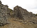
Ruins of the former village of Berich

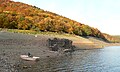
View of the lake area in which the village is under water


Outdoor property
To the west of Berich, at the mouth of the Werbe , were the Bericher Hütte, the Bericher Mühle and the Meierei Vornhagen, all of which also sank into the lake.
Bericher hut
The ironworks on Hammerberg was about 2 km west of the village on the eastern edge of the entrance to the Werbetal . The Bericher mill and a dairy were in the immediate vicinity. The ironworks was built in 1755 by the Waldeck princes. In towering blast furnaces, it mainly processed iron ore from Adorf , which was brought in by horse and cart. About 40 workers, mostly from Bringhausen , were employed in the smelting . The fuel was charcoal from the surrounding forests. The smelter's annual production in 1819 was around 160 tons of cast iron .
The iron ore smelting was stopped in December 1875 because it was no longer worthwhile due to the long transport of the products to the train station in Wabern . After that, the work fell into disrepair, partly because the building material was used for other purposes. When the Edertalsperre was built, apart from a few outbuildings, only the former residential building remained, in which an inn had been operated since 1875.
During the preparatory work for the construction of the dam, a model of the dam on a scale of 1:40 was built at the Bericher hut, on which the various devices for draining the water on the barrier wall were tried out. The water for operating the model was supplied by the mill ditch of the old hut. The foundations of the hut are still well preserved today, and when the water is low, the model of the dam still appears today. This was last the case in 2003, 2011, 2016 (only the crown), 2018 (where it was apparently deliberately damaged) and 2019.

Stollmühle
The remains of the blown up tunnel mill, a little above the ironworks, also sank into the lake. When the barrier was built they were in such a bad condition that the selling price of 70,000 marks at the time was probably quite generous. The mill nestled against the elongated Hopfenberg in the north, the top of which is now visible as an island when the water is low, and against the Hammerberg in the west. The Mühlgraben began at Vornhagen and led around the Hopfenberg; A remnant of the weir built in the Eder and part of the trench are still there. The remains of the Stollmühle are under the water ski area and cannot be dived.
Vornhagen
Vornhagen also belonged to the village of Berich, a once independent dairy that was later leased with the Waldeck domain. A large vaulted cellar and a lot of rubble are left of Vornhagen.
Personalities
- Georg Friedrich Kliffmüller (born May 25, 1803 in Berich; † January 26, 1869 there), German hereditary tenant and politician and mayor of Berich
literature
- Heinrich Schreff: The former village of Berich in Edersee, Waldeck district in Hesse . Arolsen: Waldeckischer Geschichtsverein 1960 (= Waldeck local family books 7)
Footnotes
- ↑ Only the north side wall with the five large Gothic window openings remained. ( "The ruins of the Berich Church, around 1913". Historical image documents from Hesse. In: Landesgeschichtliches Informationssystem Hessen (LAGIS).)
- ↑ Claus Peter Müller: A vacation lake appears again. In: Frankfurter Allgemeine Zeitung , July 14, 2014, p. 7.
- ↑ Low water level in the Edersee: model of the dam emerged. December 6, 2011, accessed September 23, 2016 .
- ↑ Model of the barrier wall appears from Edersee-Atlantis . In: http://www.hna.de . November 6, 2016 ( hna.de [accessed November 9, 2016]).
- ↑ Edersee-Atlantis crumbles - and is also deliberately damaged . In: https://www.hna.de . October 2, 2018 ( hna.de [accessed October 3, 2018]).
Web links
- Reporter's history: Alt-Report
- Diving map with the current state of the village of Alt-Berich
- "Berich (desert), Waldeck-Frankenberg district". Historical local dictionary for Hessen. In: Landesgeschichtliches Informationssystem Hessen (LAGIS).
- When the lost villages appear (Three Videos from Edersee-Atlantis), HNA, September 5, 2016 , accessed on November 9, 2016
Coordinates: 51 ° 11 '46.7 " N , 9 ° 2' 2.4" E