Betanzos (Bolivia)
| Betanzos | ||
|---|---|---|
 Fest in Betanzos |
||
| Basic data | ||
| Residents (state) | 4632 pop. (2012 census) | |
| rank | Rank 98 | |
| height | 3327 m | |
| Post Code | 05-0301-0100-1001 | |
| Telephone code | (+591) | |
| Coordinates | 19 ° 33 ′ S , 65 ° 27 ′ W | |
|
|
||
| politics | ||
| Department | Potosí | |
| province | Province of Cornelio Saavedra | |
| climate | ||
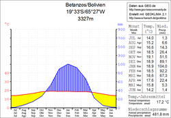
 Climate diagram Betanzos |
||
Betanzos is a small town in the Potosí department in the South American Andean state of Bolivia .
Location in the vicinity
Betanzos is the central place of the district ( Bolivian : Municipio ) Betanzos and capital of the province Cornelio Saavedra and is located at an altitude of 3327 m in the Bolivian highlands. It is located on the road between Potosí and Sucre , 48 kilometers east of the city of Potosí, on the Río Lajasmayu . An important thoroughfare led through this valley as early as the Inca times, and the cave paintings in the paleontological sites of Lajasmayu indicate an early settlement in pre-Inca times .
geography
Betanzos lies between the Bolivian Altiplano in the west and the Cordillera Central in the east. The climate of the region is a typical time of day climate , in which the temperature fluctuations during the day are greater than during the year.
The annual average temperature in the valleys of the region is around 17 ° C (see Betanzo's climate diagram), the monthly values fluctuate only slightly between 14 ° C in June / July and 19 ° C from November to January. The annual rainfall is almost 500 mm, the months May to September are arid with monthly values below 15 mm, only in January a rainfall of 100 mm is reached.
Transport network
Betanzos is located 31 kilometers by road east of Potosí , the capital of the department.
The supraregional highway Ruta 5 leads through Betanzos, which leaves Ruta 7 , which runs north-south along the Cordillera Oriental , at La Palizada and heads south-west to the Chilean border. The Ruta 5 passes the cities of Aiquile , Sucre and Yotala , crosses the Río Pilcomayo and reaches Betanzos after a total of 407 kilometers. From here it leads over Potosí, Ticatica , Pulacayo and Uyuni for another 491 kilometers to Chile.
population
The population of the village has increased by around two thirds in the past two decades:
| year | Residents | source |
|---|---|---|
| 1992 | 2,866 | census |
| 2001 | 4 168 | census |
| 2010 | 4,632 | census |
Individual evidence
- ↑ INE - Instituto Nacional de Estadística Bolivia 1992 ( Memento of the original from April 23, 2014 in the Internet Archive ) Info: The archive link was inserted automatically and has not yet been checked. Please check the original and archive link according to the instructions and then remove this notice.
- ↑ INE - Instituto Nacional de Estadística Bolivia 2001 ( Memento of the original from February 15, 2017 in the Internet Archive ) Info: The archive link was inserted automatically and has not yet been checked. Please check the original and archive link according to the instructions and then remove this notice.
- ↑ INE - Instituto Nacional de Estadística Bolivia 2012 ( Memento of the original from July 22, 2011 in the Internet Archive ) Info: The archive link has been inserted automatically and has not yet been checked. Please check the original and archive link according to the instructions and then remove this notice.
Web links
- Relief map 6535-III of the Betanzos region 1: 50,000 (PDF; 2.29 MB)
- Relief map of the Sucre region 1: 250,000 (PDF; 11.79 MB)
- Municipio Betanzos - General Maps No. 50301
- Municipio Betanzos - detailed map and population data (PDF; 735 kB) ( Spanish )
- Department Potosí - social data of the municipalities (PDF; 5.23 MB) ( Spanish )
