
Paphos district
| Επαρχία Πάφου Baf kazası
district of Paphos |
|
|---|---|
  |
|
| Basic data | |
| Country | Cyprus |
| Capital | Paphos |
| surface | 1393 km² |
| Residents | 88,266 |
| density | 63 inhabitants per km² |
| ISO 3166-2 | CY-05 |
| Website | www.moi.gov.cy (English) |
| politics | |
| Head of government | Andreas S. Christodoulides |
Coordinates: 34 ° 50 ' N , 32 ° 35' E
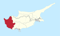
The Paphos District is a district of the Republic of Cyprus in the west of the Mediterranean island of Cyprus . The district is divided into four boroughs: Paphos (main town), Yeroskipou , Peyia and Polis Chrysochous . Other villages are z. B. Pano Akourdaleia and Terra .
The district has an area of 1393 km² , corresponding to 15.1% of the island.
The coasts are characterized by bays , capes and smaller peninsulas . The district is divided into three geographic regions: the coastal region, the hilly region and the mountain region.
The Paphos District is the only district over which the Republic of Cyprus has full control.
Communities
According to the Statistical Service of the Republic of Cyprus, the Paphos District consists of 4 cities and 121 municipalities. Cities are shown in bold.
- Acheleia
- Agia Marina Chrysochous
- Agia Marina Kelokedaron
- Agia Marinouda
- Agia Varvara
- Agios Dimitrianos
- Agios Georgios
- Agios Ioannis
- Agios Isidoros
- Agios Nikolaos
- Akoursos
- Amargeti
- Anadiou
- Anarita
- Androlikou
- Argaka
- Arminou
- Armou
- Asprogia
- Axylou
- Chlorakas
- Choletria
- Choli
- Choulou
- Chrysochou
- Drouseia
- Drymou
- Eledio
- Empa
- Episkopi
- Evretou
- Faleia
- Fasli
- Fasoula
- Filousa Chrysochous
- Filousa Kelokedaron
- Foinikas
- Fyti
- Galataria
- Geroskipou
- Gialia
- Giolou
- Goudi
- Ineia
- Kallepeia
- Kannaviou
- Karamoullides
- Kathikas
- Kato Akourdaleia
- Kato Arodes
- Kedares
- Kelokedara
- Kidasi
- Kissonerga
- Koili
- Koilineia
- Konia
- Kouklia
- Kourdaka
- Kritou Marottou
- Kritou Tera
- Kynousa
- Lapithiou
- Lasa
- Lemona
- Lemba
- Letymvou
- Livadi
- Loukrounou
- Lysus
- Makounta
- Mamonia
- Mamountali
- Mandria
- Marathounta
- Chestnuts
- Meladeia
- Melandra
- Mesa Chorio
- Mesana
- Mesogi
- Milia
- Miliou
- Mousere
- Nata
- Nea Dimmata
- Neo Chorio
- Nicokleia
- Paphos
- Pano Akourdaleia
- Pano Archimandrita
- Pano Arodes
- Pano Panagia
- Pegeia
- Pelathousa
- Pentalia
- Peristerona
- Pitargou
- Polemic
- Polis
- Pomos
- Praitori
- Prastio
- Psathi
- Salamiou
- Sarama
- Simou
- Skoulli
- Souskiou
- Statos-Agios Fotios
- Stavrokonnou
- Steni
- Stroumpi
- Tala
- Terra
- Theletra
- Thrinia
- Timi
- Trachypedoula
- Tremithousa
- Trimithousa
- Tsada
- Vretsia
- Zacharia
Individual evidence
- ↑ GEO_CODES-2015 (Download, Excel)