
Biała (Vistula)
|
Bialka Biała |
||
 Bialka River in Bielsko-Biała |
||
| Data | ||
| location | Poland | |
| River system | Vistula | |
| Drain over | Vistula → Baltic Sea | |
| source |
Klimczok , Szyndzielnia and Magura, in the Silesian Beskids 49 ° 44 ′ 37 ″ N , 18 ° 59 ′ 45 ″ E |
|
| Source height | 800 m above sea level NN | |
| muzzle | in the Vistula near Czechowice-Dziedzice Coordinates: 49 ° 56 '52 " N , 19 ° 1' 35" E 49 ° 56 '52 " N , 19 ° 1' 35" E |
|
| Mouth height | 242 m above sea level NN | |
| Height difference | 558 m | |
| Bottom slope | 20 ‰ | |
| length | 28.6 km | |
| Catchment area | 139 km² | |
| Big cities | Bielsko-Biała | |
| Medium-sized cities | Czechowice-Dziedzice | |
The Biała (German Bialka) is a right tributary of the Vistula in southern Poland. Its length is 28.6 km, the catchment area covers 139 km². It rises on the slopes of the Klimczok , Szyndzielnia and Magura mountains (at an altitude of 800 m) in the Silesian Beskids . It flows into the Vistula at a height of 242 m near Czechowice-Dziedzice. The main tributaries are: Olszówka, Straconka, Niwka, Krzywa and Kromparek.
The name in Polish is the feminine adjective for white color .
The following cities and towns are on the river: Bystra , Bielsko-Biała , Mikuszowice , Komorowice , Czechowice-Dziedzice , Bestwina and Kaniów .
For many centuries the Bialka was the border river between the historical areas of Silesia and Lesser Poland ( Galicia since 1772 ) and between the old dioceses of Wroclaw and Cracow. Since 1315 the river formed the border between the Silesian duchies of Teschen and Auschwitz (originally in Lesser Poland). Therefore, the two cities of Bielsko (Bielsko) and Biala (Biała) were separated. The merger did not take place until 1951.
Today, the entire area around the river belongs to the Silesian Voivodeship and the Bielsko-Żywiec diocese , so the border is only historical.

Biała in the 18th century
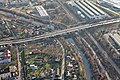
Biała in Komorowice
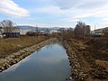
Biała in Kaniów


.jpg)