Biberbach (Danube)
| Biberbach | ||
|
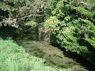
The Biberbach in Langenenslingen shortly after its origin |
||
| Data | ||
| Water code | DE : 11334 | |
| location |
Danube-Ablach plates
|
|
| River system | Danube | |
| Drain over | Danube → Black Sea | |
| source | at the north-western end of Langenenslingen 48 ° 9 '11 " N , 9 ° 22" 19 " E |
|
| Source height | approx. 570 m above sea level NN | |
| Spring discharge |
MNQ MHQ |
80 l / s 560 l / s |
| muzzle | east of Altheim from the left into the Danube Coordinates: 48 ° 8 '34 " N , 9 ° 28' 10" E 48 ° 8 '34 " N , 9 ° 28' 10" E |
|
| Mouth height | approx. 530 m above sea level NN | |
| Height difference | approx. 40 m | |
| Bottom slope | approx. 4.4 ‰ | |
| length | 9.1 km | |
| Catchment area | 80.602 km² | |
| Left tributaries | Altbach | |
| Right tributaries | Langwatte , Soppenbach | |
The Biberbach is a left tributary of the Danube in the Biberach district in Baden-Württemberg .
Beaver spring
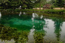
At the northwest end of Langenenslingen the Biberbach rises in a karst spring . The bluish shimmering spring pot is privately owned by the Upper Mill. It has a diameter of approx. 20 m. The water comes from the level of the cement marl of the Weißjura . The artesian groundwater occurs with a bed of 80 l / s to 560 l / s to light. The fill was enough to operate a mill since at least the 13th century. Today the source is used for private electricity generation .
course
Already in Langenenslingen the Biberbach gets its first inflow from the Karstbach Langwatte , which comes from the west in the foothills of the Swabian Alb . Following its main eastward direction of flow, the stream now crosses the Andelfingen district and receives further inflow through the Soppenbach with the Holzbach . The third tributary, the Altbach , comes from the north between Andelfingen and Altheim . In Altheim the Biberbach bends south and then flows in an arc to the north from the left into the Danube, 9.1 km below its source.
literature
- District of Biberach (Ed.): Cycling and hiking map - With leisure information and the hiking trails of the Swabian Alb Association . (Scale 1: 50,000), 1997.
Web links
Individual evidence
- ^ Hans Graul : Geographical land survey: The natural space units on sheet 179 Ulm. Federal Institute for Regional Studies, Bad Godesberg 1952. → Online map (PDF; 4.8 MB)
- ↑ a b State Institute for the Environment Baden-Württemberg (LUBW) ( information )
- ^ Ministry for the Environment, Nature Conservation and Transport Baden-Württemberg

