Bieberer Berg
| Bieberer Berg | ||
|---|---|---|
|
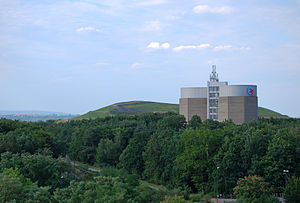
Elevated water reservoir on the Bieberer Berg. In the background the Schneckenberg. |
||
| location | Hessen , Germany | |
| Coordinates | 50 ° 5 '53 " N , 8 ° 48' 12" E | |
|
|
||
The Bieberer Berg is a clear range of mountains with high plateaus in the otherwise flat lower valley . The survey is located in the area of the independent city of Offenbach am Main in Hesse . Directly connected with the name is the Sparda-Bank-Hessen-Stadion and before that the stadium at Bieberer Berg (both home arenas of the Offenbacher Kickers ).
location
The Bieberer Berg is located between the core city of Offenbach and the eponymous district of Bieber . To the north of the Main lies the Offenbach district of Bürgel . The Buchhügel is a foothill of the Bieberer mountain that extends to the west. Here is a cold air corridor, which is important for the city, and the Offenbach weather park with a lookout tower.
The highest elevation of the actual Bieberer Berg is 130 meters above sea level and is located in the Bürgel area. Nevertheless, he calls himself Bieberer Berg, because the place Bieber is closest to him. Until 1819 , almost its entire area lay on the ground of the medieval Biebermark (with the exception of the southern slope, where the Bieberer Feldflur was already located). Only with the dissolution of the Markgenossenschaft was the area added to the Bürgel district.
history
On the summit of the Bieberer Berg, where today's stadium is located, was the parade ground for the 168 Infantry Regiment established in 1897 until 1919 . Sports clubs (including Kickers Offenbach ) were allowed to use the space beforehand on Saturdays and Sundays . After the dissolution of the regiment with its barracks in Bieberer Straße (today the tax office and food discounter), the western part became the sports field for the kickers, the eastern part became an allotment garden (Kleingartenverein Ost eV). At the beginning of the 1970s, the allotment gardens had to be given up again, as the entrance and exit for the federal road 448 with the parking lot in between were created at this point . The allotment garden association has since had its domicile at Erlensteg in Bieber in the vicinity of an allotment garden association that was previously located there.
The remains of a shooting range to the west of the stadium and trenches to the north in the forest (former training trenches) still bear witness to the earlier military use of the area.
geology
Geologically, the Bieberer Berg is a dry limestone layer from the Miocene . There used to be several limestone quarries here. In the western limestone quarry, lime was mined to a depth of up to 20 meters until around 1920. Towards the end of the Second World War, the quarry was filled with rubble. Household, commercial and industrial waste was added later. On June 3, 1967, the Tambourbad open-air swimming pool opened there on 48,000 square meters . The bathroom was so called because on that site until 1919, among others, a military band with their drummers ( drummers ) practiced. The construction cost 3.4 million German marks and was for a long time one of the most modern baths in Hesse. An air dome has been used in winter since 1972 . However, due to the toxic gases from the garbage deposits rising from the floor, the bath had to be closed again in March 1994 after only 27 years of operation. The former swimming pool area and the adjacent wasteland were expanded into the Wiener Ring sports center .
Another quarry was later also backfilled and is known as the Grix landfill . This was shut down by the Grix company in 1962 after 25 years of limestone mining. The backfilling was advanced so far that a hill now rises on the former quarry: the Schneckenberg , which at 166 meters above sea level marks the highest point in Offenbach. Extensive renovation work was carried out here within six years up to 2005. It was the largest implementation project of the capillary barrier sealing concept in Germany. The costs amounted to 15.5 million euros. The site will remain closed to the public in the future as toxic gases continue to be emitted here. The surface layer consists of 46,000 cubic meters of Rhine sand and is only 50 cm thick. At the end of 2012, a photovoltaic system costing around four million euros with 12,832 solar modules and around three megawatts of power was built on the south side of the site. Previously, it had been considered to use the mountain as a toboggan slope, excursion destination, biotope or even as a ski slope.
In the 19th century, several tunnels were cut into the limestone, which were used to store river ice from the Main. The main customers were breweries. Even today, the function from that time gives its name to the Bierbrauerweg , where most of the entrances to the tunnels are located.
The limestone quarries could have been used as early as Roman times. A Roman lime distillery is believed to be just 400 meters away at the former tube mill (later the Hoechst paintworks, now Cassella). The burnt lime could have been loaded from a ship landing stage on the Main that was suspected by Bürgel.
That this is a very calcareous area can be seen every winter in the Bieberer Feld. Larger limestone chunks are then visible everywhere in the open fields. The field was therefore often used as a meadow orchard in the past , since apple trees in particular thrive on calcareous soils. Hence the Bieber apple wine
Bieber observation tower
From the 24 meter high Bieberer observation tower on the Bieberer Berg you have a wide view of the Spessart and the Frankfurt skyline. Although the tower stands just under ten meters from the Bieber district boundary on the Rumpenheim area and was built in 1882 by the Offenbach Beautification Association, it is called the Bieber observation tower - probably because of its geographical proximity to Bieber and its location on the Bieberer Berg. From May to September the tower can be climbed on Sundays and public holidays.
nature
The northern slope of the Bieberer Berg is now completely built up. With the exception of the football stadium, the “summit” is undeveloped. Here is the Leonhard-Eißnert-Park and the forest park, a landscape protection area . The so-called “Amerikawald” towards Buchhügel and the Lohwald to the northeast of the Bieberer Berg are landscape protection areas.
Offenbach am Main water tower
On the other side of the feeder of the B 448 - next to the Schneckenberg - is the Offenbach am Main water tower of Energieversorgung Offenbach (EVO) , which can also be seen from afar . It is a 45 meter high double tower that can store 2 × 7,500 cubic meters of water. Due to its location on the Bieberer Berg, high-altitude residential areas can also be supplied.
Biker facility
In addition to the elevated water tank, on the edge of the Lohwald, a popular biker facility with all the chicanes was created by fans of cycling. The establishment has so far been tolerated by the responsible forestry office and the Offenbach city administration, although it is an unauthorized interference with nature and landscape in the landscape protection area. By driving off the beaten track, the valuable beech forest, especially the native, strictly protected orchid and butterfly species, is permanently impaired.
Leonhard-Eißnert-Park
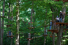
In the Leonhard-Eißnert-Park , a 22-hectare public park right next to the Kickers Stadium, a climbing facility is operated by a private investor. On the approximately three hectare site, more than 140 trees at a height of five to fifteen meters were connected with around 12,000 meters of steel cables and bridges. Here, too, the interests of the landscape protection area must be taken into account. All platforms and ropes cannot be drilled, but have to be wedged. The park also houses the Offenbach youth traffic school run by the Hessian police and a skating facility.
Individual evidence
- ↑ Printed matter I (A) 622. On: pio.offenbach.de , January 23, 2004, accessed on May 7, 2015.
- ^ Karl Keller: The parade ground. In: Offenbach History Association: Alt-Offenbach. Issue 32, 1996 (sheets of the Offenbacher Geschichtsverein), pp. 16-19.
- ↑ Matthias Dahmer: Bagger bite with a lot of nostalgia. In: op-online.de . August 31, 2009, accessed May 7, 2015 .
- ↑ Then the "tens" falls. In: op-online.de. September 1, 2009, accessed May 7, 2015 .
- ↑ a b Matthias Dahmer: Offenbach's largest photovoltaic system is to be built on the former Grix landfill. In: op-online.de. July 31, 2009, accessed May 7, 2015 .
- ↑ Offenbach am Main - portrait in numbers. (PDF; 388 kB) (No longer available online.) In: offenbach.de. City of Offenbach am Main, Public Relations Office, 2012, archived from the original on September 24, 2015 ; accessed on October 6, 2015 . According to other sources, 179 meters.
- ↑ dpa : Ex-garbage dump gets solar system - construction starts this week. (No longer available online.) In: echo-online.de . October 8, 2012, archived from the original on May 18, 2015 ; accessed on May 7, 2015 . Info: The archive link was inserted automatically and has not yet been checked. Please check the original and archive link according to the instructions and then remove this notice.
- ↑ Matthias Dahmer: Schneckenberg now solar hill. In: op-online.de. December 5, 2012, accessed May 7, 2015 .
- ↑ Johann Geiß: On the trail of the prehistory. In: Offenbacher Geschichtsverein: Offenbacher Geschichtsblätter No. 32 , 1982, ISSN 0471-122X , p. 67 ff.
- ↑ 128 steps to the beauty of the vastness. In: offenbach.de. Archived from the original on March 5, 2016 ; Retrieved July 29, 2016 .


