Birkenhead (New Zealand)
| Birkenhead | ||
| Geographical location | ||
|
|
||
| Coordinates | 36 ° 49 ′ S , 174 ° 44 ′ E | |
| Region ISO | NZ-AUK | |
| Country |
|
|
| region | Auckland | |
| District | Auckland Council | |
| Ward | North Shore Ward | |
| Local foundation | 1883 | |
| Residents | 11 871 (2013) | |
| height | 70 m | |
| Post Code | 0626 | |
| Telephone code | +64 (0) 9 | |
| Photography of the place | ||
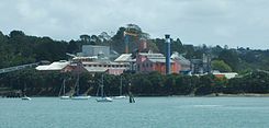
 Chelsa sugar refinery |
||
Birkenhead is a district of the former independent city of North Shore City on the North Island of New Zealand . The district has been part of the Auckland Council since November 2010.
Origin of name
Birkenhead may have been named after the town of the same name on the River Mersey across from Liverpool . The English Birkenhead was at that time for its elegant and expensive houses, its lake and its picturesque park in New York City 's Central Park was copied known.
geography
Birkenhead is located on the north coast of Waitemata Harbor , four kilometers northwest of downtown Auckland and is now administratively part of the North Shore Ward . The southern part of the suburb, Birkenhead Point , sits on a promontory between Chelsea Bay and Little Shoal Bay , one kilometer west of the north entrance to Auckland Harbor Bridge . To the north are the suburbs of Northcote and Highbury , to the west of Chatswood and the Chelsea business premises . In the south-east, south and south-west direction, the place borders on Waitemata Harbor .
history
Birkenhead was an independent city and borough until it was incorporated into North Shore City . This included the areas of Birkenhead Point, Highbury, Chatswood, Verrans Corner, Birkdale and Beach Haven .
Birkenhead was described in the New Zealand Herald in 1883 as "wild and desolate", was separated from the city of Auckland by the harbor and was sparsely populated. In 1882 the site was chosen as the site for New Zealand's only sugar refinery , the Chelsea Sugar Refinery , construction of which began in 1883. The company built houses for many of its workers, creating the suburb of Birkenhead . The refinery was the area's main employer for many years and continues to this day.
The place was overgrown by kauri trees before it was settled . Since the resin from the trees was still in the ground, gumdiggers (people who dug for resin) were temporarily stored in the area looking for the fossil kauri resin from the trees. Families from Auckland took the ferry across Waitemata Harbor at the weekend to dig for Harz in the fields around Birkenhead . This caused damage to the streets and farms, so that the search for resin was later regulated by the city council.
Birkenhead was one of several areas around the North Shore that were popular residential areas with the middle class. These, usually skilled workers or business people, used the ferry service via Auckland Harbor to Auckland as commuters . The wharves at Devonport, Northcote and Birkenhead were very busy until 1959 when the Auckland Harbor Bridge was built to change the situation. However, the ferry to Birkenhead was put back into service in the 1980s and grew in popularity as the traffic jams on the bridge increased.
education
Birkenhead has two primary schools, the Birkenhead School and the Verran Primary School , both of which are co-educational primary schools for grades 1 to 6 with a decile rating of 10 and 7 and 341 and 243 students respectively. The Birkenhead School was founded in 1919 as a branch of the Northcote School in Auckland, the Verran Primary School was founded in 1964.

Personalities
- Clement Lindley Wragge , the meteorologist who introduced the naming of cyclones after people, spent his final years at 8 Awanui Street
- Son Rudall , former New Zealand filmmaker ( Rewi's Last Stand )
- Hone Tuwhare (1922–2008), poet and brief member of Birkenhead City Council
literature
- Margaret McClure : The Story of Birkenhead . Ed .: Birkenhead City Council . Birkenhead 1987 (English).
- Terence Hodgson : The Heart of Colonial Auckland . Random Century NZ Ltd , 1992 (English).
Individual evidence
- ↑ 2013 Census QuickStats about a place: Devonport - Takapuna . Statistics New Zealand , accessed on May 23, 2017 (English, StatsMap: Meshblock analysis from the interactive map for Birkenhead , Chelsa and Kauri - Park ).
- ^ McClure : The Story of Birkenhead . 1987, p. 55 f .
- ^ About The School - School History . Birkenhead Primary School , archived from the original on June 2, 2010 ; Retrieved on August 8, 2014 (English, original website is no longer available, a link to the Wayback Machine of the Internet Archive ).
- ^ History . Verran Primary School , archived from the original on March 21, 2009 ; Retrieved on August 8, 2014 (English, original website is no longer available, a link to the Wayback Machine of the Internet Archive ).
