Birkertsbach
| Birkertsbach | ||
|
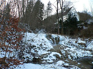
Weissenbrunn sinter terraces in front of the forest |
||
| Data | ||
| location | Germany | |
| River system | Rhine | |
| Drain over | Itz → Main → Rhine → North Sea | |
| source | on the Schalkau plateau near Weißenbrunn in front of the forest 50 ° 35 ′ 57 ″ N , 11 ° 0 ′ 0 ″ E |
|
| Source height | approx. 434 m above sea level NHN | |
| muzzle | east of Weißenbrunn vorm Wald in the Itz in the immediate vicinity of the Froschgrundsee Coordinates: 50 ° 35 ′ 46 ″ N , 11 ° 2 ′ 40 ″ E 50 ° 35 ′ 46 ″ N , 11 ° 2 ′ 40 ″ E |
|
| Mouth height | approx. 345 m above sea level NHN | |
| Height difference | approx. 89 m | |
| Bottom slope | approx. 55 ‰ | |
| length | 1.6 km | |
| Right tributaries | Watersle | |
The Birkertsbach is a 1.6 km long and right tributary of the Itz in Weißenbrunn vorm Wald .
geography
course
The Birkertsbach rises west of Weißenbrunn vorm Wald at an altitude of about 434 m above sea level. NN at the foot of the Koppelsberg. After 200 m it crosses Emstadter Straße, another spring follows on the left. Now it overcomes fifteen meters in altitude in a four-tier waterfall and forms the Weißenbrunn lime sinter terrace.
It finally joins the Itz east of Weißenbrunn vorm Wald at an altitude of about 345 m in close proximity to the Froschgrundsee .
A mean bed gradient of 55 ‰ is calculated from the height difference of 89 meters. It drains its catchment area via Itz, Main , Rhine to the North Sea .
Tributaries
- Wässerle ( right ), 0.3 km
