Pear tree pond
| Birnbaumteich Birnbaumer Teich, Bernburger Teich |
|||||||||
|---|---|---|---|---|---|---|---|---|---|
|
|||||||||
|
|
|||||||||
| Coordinates | 51 ° 36 '51 " N , 11 ° 5' 28" E | ||||||||
| Data on the structure | |||||||||
| Lock type: | Earth dam with core seal | ||||||||
| Construction time: | 1699 (original) , 1964–1967 (new building) |
||||||||
| Height above valley floor: | 12.6 m | ||||||||
| Height above foundation level : | 13.4 m | ||||||||
| Height of the structure crown: | 398.5 m | ||||||||
| Building volume: | 30th 000 m³ | ||||||||
| Crown length: | 144 m | ||||||||
| Crown width: | 8 m | ||||||||
| Base width: | 5 to 10 m | ||||||||
| Slope slope on the air side : | 1: 2 | ||||||||
| Slope slope on the water side : | 1: 2 | ||||||||
| Operator: | Saxony-Anhalt dam operation | ||||||||
| Data on the reservoir | |||||||||
| Altitude (at congestion destination ) | 396.69 m | ||||||||
| Water surface | 4.5 ha (0.045 km²) | ||||||||
| Reservoir length | 320 m | ||||||||
| Reservoir width | 130 m | ||||||||
| Storage space | 0.17 million m³ | ||||||||
| Total storage space : | 0.198 million m³ | ||||||||
| Catchment area | 1.88 km² | ||||||||
| Design flood : | 2.4 m³ / s | ||||||||
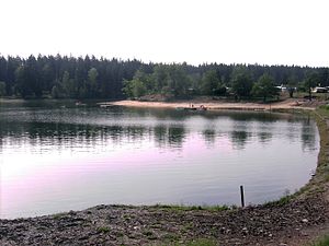
The pear tree pond , also known as the Bernburger pond , is a historic dam in the Harz district of Saxony-Anhalt . It is located in the Harz near Neudorf . The 4.5 hectare reservoir with a 144 m long dam is part of the Unterharzer pond and ditch system . The operator is the dam operation of Saxony-Anhalt .
Geographical location
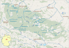
The pear tree pond is located in the middle Lower Harz in the Harz Nature Park . It is located 2 km west-north-west of the village church of the Harzgeroder district of Neudorf and 0.8 km northeast of the Birnbaum desert .
The pond is traversed by the Birnbaumbach , which flows below the dam to the nearby Selke . To the northwest below the pear tree pond are the pear tree and Heller grounds. The latter is included as no. 194 in the system of stamping points of the Harz hiking pin; the stamping point is at a tributary of the Birnbaumbach on the left.
The Birnbaumteich holiday park with a campsite and bathing area is located between the Birnbaum desert and the pond .
Location of the dam in the Harz Mountains |
history
The dam was completed in 1699 and put into operation for mining in the Neudorf district. From 1779 the calf's eye pond served as an additional storage facility for the pear tree pond . In 1963 a damaged spot in the dam and a no longer functional harrow of a harrowing system were discovered. Therefore, the dam was largely rebuilt from 1964 to 1967. The bottom outlet was also renewed. In 1967 the dam was put back into operation. Since then, the pond has been used for fishing, flood protection and local recreation. In the summer of 2006, the dam was renovated.
Dam and reservoir
The dam is an earth dam with a core seal and 30,000 m³ structure volume. It is 144 m long, 13.4 m high and 5 to 10 m wide; the dam crest is 398.5 m high. The seal consists of turf in the old part , and clay in the new part at the bottom outlet . The flood relief on the right slope has a pipe passage with a diameter of 1 m.
The reservoir is 4.5 hectares (0.045 km²) in size, 320 m long and 130 m wide. It has 0.17 million m³ of storage space and a total storage space of 0.198 million m³. Its catchment area is 1.88 km². The reservoir target is 396.69 m high and the design flood is 2.4 m³ / s.
See also
Individual evidence
- ↑ a b c d e f g h i j k l The pear tree pond, on harzlife.de
- ↑ a b c d e f g h i j Birnbaumteich (and other dams), in the north area , on talsperren-lsa.de
- ↑ Harzer Wanderadel: Stamp 194 / Hellergrund , on harzer-wandernadel.de
literature
- Robert Wouters: Dams in Saxony-Anhalt . Ed .: Saxony-Anhalt dam operation. mdv, Halle (Saale) 2010, ISBN 978-3-89812-677-9 .
- Development and current function of systems of historical mining water management in the Lower Harz . In: Wilfried Strenz, Working Group Historical Geography of the Geographical Society of the GDR (ed.): Historical-geographical research in the GDR . Hermann Haack Geographisch-Kartographische Anstalt, Gotha 1986, ISBN 3-7301-0803-4 .


