Bittingen
|
Bittingen
Ense municipality
Coordinates: 51 ° 30 ′ 34 " N , 8 ° 1 ′ 11" E
|
|
|---|---|
| Height : | 200–250 m above sea level NN |
| Residents : | 104 (Dec. 31, 2019) |
| Incorporation : | 1st July 1969 |
| Postal code : | 59469 |
| Area code : | 02928 |
|
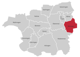
Location of Bittingen in Ense
|
|
Bittingen is a part of the municipality of Ense in the Soest district. Am Haarstrang , between Möhne and Ruhr , the place is on the northern edge of the Sauerland. Werl is approx. 10 km away, Soest approx. 8 km. For recreation area Möhnesee is about 6 km. Together with Gerlingen and Bilme, the place is one of the least populated districts of Ense.
history
If there was a fire in earlier times, the fire had to be reported at the Frieling farm , this was the fire alarm center .
The water supply for the village and the surrounding area was guaranteed by the Bittinger spring .
In the course of the local reorganization on July 1, 1969, Bittingen was combined with 13 other independent places to form the new municipality of Ense.
Well-known citizens of the village
- Eberhard Viegener (1890–1967), painter and graphic artist, has lived here since 1920.
- Alex Brunnberg (1915–1989), local politician, district administrator of the Höxter district and board member of the Westphalian-Lippian Savings Banks and Giro Association
Web links
Individual evidence
- ↑ Municipality of Ense: Figures, data, facts , accessed on March 2, 2020
- ↑ Martin Bünermann: The communities of the first reorganization program in North Rhine-Westphalia . Deutscher Gemeindeverlag, Cologne 1970, p. 90 .
