
Björlanda and Torslanda
| Björlanda and Torslanda | ||||||
|
||||||
| State : | Sweden | |||||
| Province (län): | Västra Götalands län | |||||
| Historical Province (landskap): | Bohuslan | |||||
| Municipality : | Gothenburg | |||||
| Coordinates : | 57 ° 44 ' N , 11 ° 47' E | |||||
| SCB code : | 4302 | |||||
| Status: | Crime scene | |||||
| Residents : | 23,088 (December 31, 2015) | |||||
| Area : | 19.36 km² | |||||
| Population density : | 1193 inhabitants / km² | |||||
| List of perpetrators in Västra Götaland County | ||||||

Björlanda och Torslanda is a crime scene in the Swedish province of Västra Götalands län and the historic province (landskap) Bohuslän . It extends about ten kilometers west to northwest of the center of the provincial capital Gothenburg on the island of Hisingen , which lies between the Göta älv and its right arm, Nordre älv, when it flows into the Kattegat .
The scene of the crime was reported for the first time in 2015 by the Statistiska centralbyrån . It encompasses the virtually continuously built-up area in the western part of the island of Hisingen, which is separated from the scene of the crime in Gothenburg by the Gothenburg seaport on the north side of the mouth of the Göta älv, adjoining industrial areas and the extensive area of the Volvo plant in Torslanda and has become from the previously independent ones The perpetrators Torslanda, Hjuvik , Kvisljungeby, Björlanda, Låssby and Trulsegården as well as the areas in between were formed (descending according to the number of inhabitants in 2010; Torslanda was listed as a crime scene under Nolered in 1970 and 1975 and in 2010 was assigned to the scene in Gothenburg).
From an administrative point of view, Björlanda och Torslanda is on the territory of the Gothenburg part of the municipality or city district (stadsdelsnämde) Västra Hisingen and comprises a large part of the area and the inhabitants of three of the eleven primary areas (primärområde) of the city district: Björlanda, Hjuvik and Nolered, with the exception of Tatvik and Nolorte Tumlehed as well as some smaller settlements.
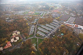
Central part of Torslanda / Nolered

Torslanda Church

Partial view of Björlanda
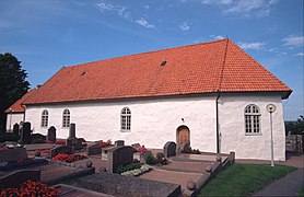
Björlanda Church

Hjuvik Harbor


Provincial road ( länsväg ) 155 runs through the southern part of the village to the ferry terminal in Hjuvik, via which the islands of the northern Gothenburg archipelago and the municipality of Öckerö are connected to the road network.
Web links
Individual evidence
- ↑ a b Statistiska centralbyrån : Land area per Tatort, folkmängd and invånare per square kilometer. Vart femte år 1960 - 2015 (database query)
Perpetrator: Angered | Asperö | Billdal (part) | Björlanda och Torslanda (with Hjuvik ) | Brännö | Donsö | Gothenburg | Gundal och Högås (part) | Gunnared och Hammarkullen | Helgered | Kungälv (part) | Nolvik | Olofstorp | Säve | Stenared | Styrsö | Tumlehed | Vrångö
Småorter: Ambjörnhagen | Assmundtorp och Skändla | Bärby | Bönered | Brunnstorpsnäs | Bruntorpsdalen och Mulered | Djupedal södra | Dockered (part) | Gunnesby | Gunnilse | Halleröd | Kålsered | Tilting bars | Köpstadsö | Kvillehed | Lerbäck | Rösbo | Skålvisered | Skeddalen | Tomtebacken och Gullö