
Vrångö
| Vrångö | ||||||
|
||||||
| State : | Sweden | |||||
| Province (län): | Västra Götalands län | |||||
| Historical Province (landskap): | Västergötland | |||||
| Municipality : | Gothenburg | |||||
| Coordinates : | 57 ° 35 ' N , 11 ° 47' E | |||||
| SCB code : | 4612 | |||||
| Status: | Crime scene | |||||
| Residents : | 351 (December 31, 2015) | |||||
| Area : | 0.5 km² | |||||
| Population density : | 702 inhabitants / km² | |||||
| List of perpetrators in Västra Götaland County | ||||||

Vrångö is an island and a place ( Tatort ) in the Swedish province of Västra Götalands län and the historic province of Västergötland . It is the southernmost, inhabited and built-up island of Gothenburg's southern archipelago , which also includes Donsö and Styrsö .
Vrångö has a long fishing tradition. Two ports are located there, one for passenger ferries operated by the shipping company Styrsöbolaget on behalf of the regional transport association Västtrafik on the eastern side and, since 2004, a new marina on the western side of the island, the construction of which was funded with EU funds. The local football club Vrångö IF plays its games on the island.
The northern and southern parts of the island have been a nature reserve since 1979. A circular hiking trail opens up the nature reserve for tourists. In particular, arable crops , sand asters and sedge thrive here . Sheep graze on the sea-covered meadowland in the north (Vidingen ). A Bronze Age burial mound ( Storerös) is hidden in the east of the island . More than 60 different bird species breed here, for example eider ducks , kestrels , eagle owls , sprouts and skylarks . For this reason, part of the island is closed to visitors between April and July. Seals live in the wild on the southern tip of the island. The nature reserve is looked after by a foundation, the Västkuststiftelsen .
Picture gallery
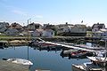
View of the old fishing port of Vrångö, Gamla Stan

Plant in the southern nature reserve of Vrångö
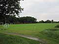
Vrångö IF football pitch in light rain

Circular walk around the island (here: NE) with a view of the archipelago and the Swedish mainland


Web links
- Vrångö Bygdegården (Swedish)
- Vrångö en skärgårdspärla i snö Report and pictures by nature photographer Björn Dahlfors (Swedish)
Individual evidence
- ↑ a b Statistiska centralbyrån : Land area per Tatort, folkmängd and invånare per square kilometer. Vart femte år 1960 - 2015 (database query)
- ↑ Vrångö IF website
- ↑ Website of the Västkuststiftelsen nature reserve
Perpetrator: Angered | Asperö | Billdal (part) | Björlanda och Torslanda (with Hjuvik ) | Brännö | Donsö | Gothenburg | Gundal och Högås (part) | Gunnared och Hammarkullen | Helgered | Kungälv (part) | Nolvik | Olofstorp | Säve | Stenared | Styrsö | Tumlehed | Vrångö
Småorter: Ambjörnhagen | Assmundtorp och Skändla | Bärby | Bönered | Brunnstorpsnäs | Bruntorpsdalen och Mulered | Djupedal södra | Dockered (part) | Gunnesby | Gunnilse | Halleröd | Kålsered | Tilting bars | Köpstadsö | Kvillehed | Lerbäck | Rösbo | Skålvisered | Skeddalen | Tomtebacken och Gullö