
Gunnared och Hammarkullen
| Gunnared och Hammarkullen | ||||||
|
||||||
| State : | Sweden | |||||
| Province (län): | Västra Götalands län | |||||
| Historical Province (landskap): | Västergötland | |||||
| Municipality : | Gothenburg | |||||
| Coordinates : | 57 ° 48 ' N , 12 ° 3' E | |||||
| SCB code : | 4364 | |||||
| Status: | Crime scene | |||||
| Residents : | 45,106 (December 31, 2015) | |||||
| Area : | 10.59 km² | |||||
| Population density : | 4259 inhabitants / km² | |||||
| List of perpetrators in Västra Götaland County | ||||||

Gunnared och Hammarkullen is a crime scene in the Swedish province of Västra Götalands län and the historical province (landskap) Västergötland . It extends about 7 to 14 kilometers north-northeast of the center of the provincial capital Gothenburg in the hilly area east of the Göta älv and lies on the territory of the Gothenburg city district (stadsdelsnämnde) - or part of the municipality of Gothenburg - Angered .
Although the city of Gothenburg is in fact subordinate to the city of Gothenburg, the location of the crime was reported separately for the first time in 2015 by the Statistiska centralbyrån , as the continuous residential development in the area is so spatially separated from that of the Gothenburg city that it corresponds to the definition of a crime scene. Gunnared och Hammarkullen roughly covers the entire area of the most populous and densely built-up primary areas (primärområde) in the western part of the city district of Angered: Agnesberg, Angereds Centrum, Eriksbo, Gårdstensberget, Hammarkullen, Hjällbo, Linnarhult, Lövgärdet and Rannebergen more rural - only the two rural primary areas in the south to east of the borough are not included; there are, among other things, the independent crime scene Angered , Olofstorp and Stenared .
The name of the crime scene is composed of the earlier (before the formation of the district of Angered 2011) designation of the northern part of the district, Gunnared, which in turn goes back to the name of the parish Gunnareds församling , which was established in 1971 during the development of the area (since 2016 also the district of the same name ), as well as the name of the largest residential area in the southern part, Hammarkullen. The place is characterized by predominantly in the 1960s to the 1970s as part of the Million Program incurred plate - and housing settlements; In the southern areas of Eriksbo, Hjällbo and Linnarhult in particular, there are also some older individual buildings.
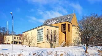
Gunnared Church, center of the eponymous parish

Millions of program buildings in Hammarkullen

Residential area Rannebergen


Individual evidence
- ↑ a b Statistiska centralbyrån : Land area per Tatort, folkmängd and invånare per square kilometer. Vart femte år 1960 - 2015 (database query)
Perpetrator: Angered | Asperö | Billdal (part) | Björlanda och Torslanda (with Hjuvik ) | Brännö | Donsö | Gothenburg | Gundal och Högås (part) | Gunnared och Hammarkullen | Helgered | Kungälv (part) | Nolvik | Olofstorp | Säve | Stenared | Styrsö | Tumlehed | Vrångö
Småorter: Ambjörnhagen | Assmundtorp och Skändla | Bärby | Bönered | Brunnstorpsnäs | Bruntorpsdalen och Mulered | Djupedal södra | Dockered (part) | Gunnesby | Gunnilse | Halleröd | Kålsered | Tilting bars | Köpstadsö | Kvillehed | Lerbäck | Rösbo | Skålvisered | Skeddalen | Tomtebacken och Gullö