Bloherfelde
|
Bloherfelde
District-free city of Oldenburg (Oldb)
Coordinates: 53 ° 8 ′ 25 ″ N , 8 ° 8 ′ 46 ″ E
|
||
|---|---|---|
| Postal code : | 26129 | |
| Area code : | 0441 | |
|
Location of Bloherfelde in Lower Saxony |
||
|
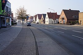
Bloherfelder Strasse
|
||
Bloherfelde is a district of the Lower Saxony city of Oldenburg (Oldb) .
geography
Bloherfelde is located in the west of the city and borders the Petersfehn district of the Ammerland community of Bad Zwischenahn , as well as the other Oldenburg districts of Wechloy and Haarentor in the north and Eversten in the south. The boundaries between Bloherfelde and Eversten are quite fluid.
The settlement areas of Bloherfeld were created along Bloherfelder Strasse . The district is characterized by the high number of trees. In addition to the green spaces, there are two larger bodies of water in the district, the Bloherfelder Teich and the Kennedyteich. In the immediate vicinity of the Bloherfeld pond is the Eversten grammar school , which bears the name of the neighboring district, but is de facto on Bloherfeld terrain, which can be seen as an indication that the categorization between Eversten and Bloherfelde is of a blurred nature.
The An den Eschen development area was built along the Hörneweg at the turn of the millennium . The settlement areas of Bloherfeld mostly consist of single-family houses. One exception is the social housing development in the Kennedy district, where high-rise buildings dominate. The presence of a district library increases the attractiveness of Bloherfeld.
It is only about one kilometer to the University of Oldenburg via Hartenscher Damm and Drögen-Hasen-Weg . The forest and local recreation area Wildenloh is also in the immediate vicinity .
history
Economy and Infrastructure
Bloherfelde is connected to the public transport network by bus route 309 from Oldenburger Verkehr und Wasser .


