Bümmerstede
|
Bümmerstede
City of Oldenburg (Oldb)
Coordinates: 53 ° 5 ′ 36 ″ N , 8 ° 12 ′ 40 ″ E
|
||
|---|---|---|
| Height : | 5 m above sea level NHN | |
| Area code : | 0441 | |
|
Location of Bümmerstede in Lower Saxony |
||
|
Bümmerstede behind the Neu-Osenberge forest, on the right at the edge of the picture the Krusenbusch embankment area
|
||
Bümmerstede is a district of the Lower Saxon city of Oldenburg (Oldb) , developed from a peasantry . Bümmerstede belonged to the municipality of Osternburg until 1922 and then to the city of Oldenburg after it was incorporated.
history
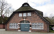
In its long history, which goes back to the 7th century, the Bümmerstedes area served as grazing land for sheep and cattle. The moor and heathland landscape offered the right conditions for this. Individual houses belonging to farming families who settled in the area in the 16th century have been preserved to this day and shape the original image in the old town center. A man number register dates from 1581, in which men from "Bümmerstedt" are listed. In its peasant role of January 20, 1746, the Bümmerstede peasantry gave itself a legal system. The oldest memorial stone in Oldenburg is located in Bümmerstede, a stele that has been commemorating the four war dead in the Wars of Liberation against Napoleon in 1813/1814 since around 1815 . Social life was dominated by two hereditary mugs, the Bümmersteder Courier and the Bümmersteder Krug .
geography
Bümmerstede forms the southernmost tip of the city of Oldenburg. The border to the neighboring district of Kreyenbrück in the north is fluid. Bümmerstede is separated from the Krusenbusch district in the east, which also belongs to Oldenburg , by the Oldenburg – Osnabrück railway line and the Krusenbusch railway embankment nature reserve . Krusenbusch can only be reached directly from Bümmerstede via the jump path. Extensive forest and meadow areas characterize the landscape. The old town center of Bümmerstede is now on its western edge in a landscape protection area . The Bümmersteder Fleth also flows here , a 10-kilometer-long watercourse that runs parallel to the Hunte from the Osenberge to the Osternburg Canal . Today there is no longer a central town center; the center of the district is arranged lengthways along the Bümmersteder Tredde . The settlement areas of Bümmerstedes, which mostly consist of single-family houses, lie in a star shape around the Tredde.
The wooded district of Klein-Bümmerstede no longer belongs to the city of Oldenburg, but to the municipality of Wardenburg . It is characterized by its village-like settlement structure and an industrial area in which, among other things, the LAVES - Lower Saxony State Office for Consumer Protection and Food Safety is based.
Bundeswehr location
A large part of the area of Bümmerstede is taken up by the Henning-von-Tresckow barracks , in which the brigade staff of Airborne Brigade 31 and parts of Airborne Support Battalion 272 were stationed for many years . The airborne brigade was disbanded in 2014. As part of the realignment of the Bundeswehr , the staff of the 1st Panzer Division was relocated from Hanover to Bümmerstede at the end of 2015 . The Bümmerstede training area, which belongs to the barracks, is located in the municipality of Hatten, as is the small district of Bümmerstede-Ost with just over 100 inhabitants .
Churches and cemetery
The Evangelical Lutheran Church maintains a community center on Erikaweg. The Catholic parish church of St. Joseph stands in the middle of the settlement of St. Peter. On the western edge of Bümmerstede is the municipal park cemetery Bümmerstede , where Buddhist, Muslim, Jewish and Yezidi grave fields are also offered.
Schools and clubs
In Bümmerstede there is a municipal primary school, a special school with a focus on emotional and social development, the FREIraum primary school , the riding and driving school Oldenburg eV, the Blau-Weiss Bümmerstede eV sports club , Budokan Bümmerstede eV and a youth center .
Public transport
The public transport connection Bümmerstedes is ensured by the bus line 304 of the Oldenburger Verkehr und Wasser GmbH , which connects the district and the Oldenburg city center every quarter of an hour.
literature
- Bernd Franken, Helga Kramp: Kreyenbrück and Bümmerstede . Isensee, Oldenburg 2004, ISBN 3-89995-148-4 .
- Lioba Müller: Oldenburg-Bümmerstede, district tour . Isensee, Oldenburg 2014, ISBN 978-3-7308-1053-8 .
Web links
Individual evidence
- ^ Walter Schaub: The first man number registers of the four Oldenburg Geestvogteien . Issue 12. Oldenburg Society for Family Studies, June 1955.
- ^ Ekkehard Seeber: Constitution of Oldenburg farmers . V & R Unipress, Osnabrück 2008.
- ^ Dietrich Hagen: Oldenburger Steinlese . Isensee, Oldenburg 1993, ISBN 3-89442-150-9 . Pages 57, 77 and 78
- ^ To the Courier von Bümmerstede , accessed on April 2, 2014.
- ↑ Joachim Schrape, Gustav labor: Gastronomy in Oldenburg . From host association to DEHOGA business association 125 years from 1882–2007. 1st edition. Medienhaus Rösemeier, Bad Zwischenahn 2007, ISBN 978-3-926294-21-0 , p. 94 .
- ^ Barracks getting ready for new staff , accessed April 12, 2014.
- ↑ Brief information about the municipality of Hatten ( Memento of the original from March 27, 2012 in the Internet Archive ) Info: The archive link has been inserted automatically and has not yet been checked. Please check the original and archive link according to the instructions and then remove this notice. Website of the municipality of Hatten, accessed December 12, 2012.


