Blue Springs, Alabama
|
|
This article was on the basis of substantive defects quality assurance side of the project USA entered. Help bring the quality of this article to an acceptable level and take part in the discussion ! A closer description on the resolving issues is missing. |
| Blue Springs | |
|---|---|
 |
|
| Location in Alabama | |
| Basic data | |
| State : | United States |
| State : | Alabama |
| County : | Barbour County |
| Coordinates : | 31 ° 40 ′ N , 85 ° 30 ′ W |
| Time zone : | Central ( UTC − 6 / −5 ) |
| Residents : | 96 (as of 2010) |
| Population density : | 12.8 inhabitants per km 2 |
| Area : | 7.5 km 2 (approx. 3 mi 2 ) of which 7.5 km 2 (approx. 3 mi 2 ) are land |
| Height : | 93 m |
| Postal code : | 36017 |
| Area code : | +1 334 |
| FIPS : | 01-07672 |
| GNIS ID : | 0154990 |
Blue Springs is a city in Barbour County in the US state of Alabama . As of the 2010 census, Blue Springs had 96 residents. The place has a total area of 7.5 km².
geography
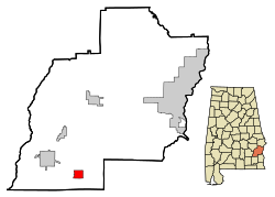
Blue Springs is located in southeast Alabama in the southern United States. The borough is almost half of the 42 ha large Blue Springs State Park . The place is about 35 kilometers west of the Georgia border and 183 square kilometer Walter F. George Lake .
Nearby places include Clio (5 km northwest), Louisville (11 km north), Bakerhill (18 km northeast) and Abbeville (20 km southeast). The next larger city with 205,000 inhabitants is the capital of Alabama, Montgomery, about 90 kilometers to the northwest .
history
The place was named after the nearby water sources. In 1902 a post office was built.
traffic
Alabama State Route 10 runs from west to east of the city and connects to US Highway 431 about 13 miles east and connects to US Highway 231 30 kilometers west .
About 23 kilometers north is Clayton Municipal Airport , 25 kilometers east of Abbeville Municipal Airport , 26 kilometers southwest of Blackwell Field Airport , 27 kilometers west of Brundidge Municipal Airport and 35 kilometers south of Dothan Regional Airport .
Demographics
As of the 2000 census , Blue Springs had 121 residents, distributed among 49 households and 35 families. The population density was 16.2 inhabitants per km ². 99.17% of the population were white, 0.83% were African American. Children under the age of 18 lived in 28.6% of households. The median income per household was $ 38,000, with 4.3% of the population living below the poverty line .
By the 2010 census , the population had dropped to 96.
Web links
- Statistical data on Blue Springs (English)
- Blue Springs in the Encyclopedia of Alabama
Individual evidence
- ↑ Place Names in Alabama , University of Alabama Press, Tuscaloosa 1989, p. 20 ( on Google Books )

