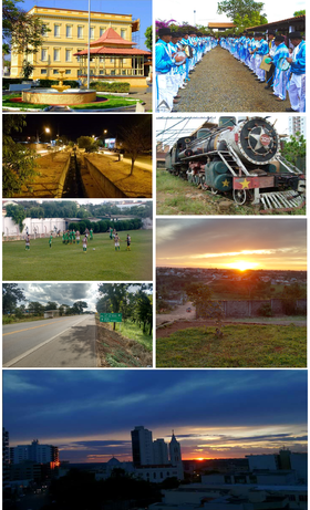
Bom Despacho
| Município de Bom Despacho Bom Despacho |
|||
|---|---|---|---|
|
|
|||
| Coordinates | 19 ° 44 ′ S , 45 ° 15 ′ W | ||
 Location of Bom Despacho in the state of Minas Gerais Location of Bom Despacho in the state of Minas Gerais
|
|||
| Symbols | |||
|
|||
|
Motto “Fé, Energia e Trabalho” Faith, strength and work |
|||
| founding | 1912 (emancipation) | ||
| Basic data | |||
| Country | Brazil | ||
| State | Minas Gerais | ||
| ISO 3166-2 | BR-MG | ||
| structure | 2 districts: Bom Despacho (headquarters), Engenho do Ribeiro | ||
| height | 768 m | ||
| climate | Cwa, tropical mountain climate | ||
| surface | 1,213.5 km² | ||
| Residents | 45,624 (2010) | ||
| density | 37.6 Ew. / km² | ||
| estimate | 50,166 (July 1, 2018) | ||
| Parish code | IBGE : 3107406 | ||
| Time zone | UTC −3 | ||
| Website | www.bomdespacho.mg.gov.br (Brazilian Portuguese) | ||
| politics | |||
| City Prefect | Fernando José Castro Cabral (2017–2020) | ||
| Political party | Partido Popular Socialista (PPS) | ||
| economy | |||
| GDP | 1,047,544 thousand R $ 21,276 R $ per person (2015) |
||
| HDI | 0.750 (2010) | ||
Bom Despacho , officially Portuguese Município de Bom Despacho , is a city in the Brazilian state of Minas Gerais (MG). It is 156 km from the capital, Belo Horizonte . According to the 2010 census by the Instituto Brasileiro de Geografia e Estatística (IBGE), the population was 45,624 people, called Bom-Despachenses ( bom-despachenses ). The population estimate of the IBGE from July 1, 2018 amounts to 50,166 residents with an area of around 1213.5 km² (2016).
history
As a district seat, the place Vila de Bom Despacho became a legally independent municipality on June 1, 1912 by hiving off from Santo Antônio do Monte .
German immigration
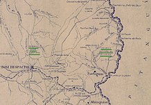
The immigration of settlers from Europe, especially from Germany, from the beginning of the 1920s is historically significant. On the initiative of the Brazilian politician Faustino Assunção, the city of Bom Despacho took part in the settlement program of the Ministry of Agriculture under the Bernardes government . As part of this settlement program, the settlers were provided with agricultural land, living space and various initial aids. The agricultural land consisted of two settlement areas that were named after Brazilian politicians; Colônia David Campista and Colônia Álvaro da Silveira . Both areas are on the outskirts of the city of Bom Despacho.
Such a large number of Germans came to the settlement that the German embassy ran a German school on the Colônia David Campista settlement, where around 50 large families lived. Since the living conditions within the settlement sometimes did not meet expectations (unproductive soil, tropical diseases), many settlers looked for work in the cities. When Brazil entered the Second World War in 1942, the German school was closed and it was forbidden to speak German, whereupon many Germans left the Colônia David Campista settlement. Today there are only a few descendants of Germans left in the two former settlements who continue to farm and speak the German language.
A cemetery in the immediate vicinity of the former settlement of Côlonia David Campista is popularly known as the German Cemetery , the official name on the entrance gate is Imigrantes da Colonia .
City administration
The executive rests with the prefecture of the city ( Prefeitura Municipal ). City prefect (mayor) has been Fernando José Castro Cabral of the Partido Popular Socialista (PPS) for the 2017 to 2020 term of office since the local elections in 2016 . The legislature lies with the city council ( Câmara Municipal ) made up of nine elected city councilors ( vereadores ).
structure
Bom Despacho is divided into two districts (seat, Engenho do Ribeiro), on the territory of the municipality there are 11 villages.
Personalities
Born in Bom Despacho:
- Waldemar Chaves de Araújo (* 1934), bishop
Web links
- City Prefecture website , Prefeitura Municipal (Brazilian Portuguese)
- City Council website , Câmara Municipal (Brazilian Portuguese)
- Information on German immigration, in Portuguese
Individual evidence
- ↑ a b IBGE : Bom Despacho - Panorama . Retrieved June 2, 2018 (Brazilian Portuguese).
- ↑ Estimativas da população residente no Brasil e unidades da federação com data de referência em 1 ° de julho de 2018. (PDF; 2.6 MB) In: ibge.gov.br. Instituto Brasileiro de Geografia e Estatística (IBGE), 2018, accessed September 29, 2018 (Brazilian Portuguese).
- ↑ IBGE : Bom Despacho - Histórico. In: cidades.ibge.gov.br. Retrieved June 2, 2018 (Brazilian Portuguese).
- ^ Prefeitura Municipal de Bom Despacho: Histórico. In: www.bomdespacho.mg.gov.br. Retrieved August 27, 2019 (Brazilian Portuguese).
- ↑ Fernando Cabral 23 (Prefeito). In: com.br. Eleições 2016, accessed June 2, 2018 (Brazilian Portuguese).


