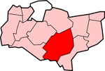
Borough of Ashford
| Borough of Ashford | |
|---|---|
 Location in Kent |
|
| status | Borough |
| region | South East England |
| Administration County | Kent |
| Administrative headquarters | Ashford |
| surface | 580.62 km² (82.) |
| Residents | 112,500 (189.) |
| ONS code | 29UB |
| Website | www.ashford.gov.uk |
Ashford is an administrative district with borough status in Kent in England . In addition to the city of Ashford , the administrative center, it also includes numerous villages in the area; the second largest town is Tenterden . The district is still largely rural, but is increasingly becoming an important industrial and service center. The reason is the Channel Tunnel Rail Link and Ashford International station , where numerous Eurostar trains stop.
The district was formed on April 1, 1974 and was formed from the merger of Borough Tenterden, Urban District Ashford and the rural districts of East Ashford, West Ashford and Tenterden.
Coordinates: 51 ° 9 ′ 0 ″ N , 0 ° 52 ′ 3 ″ E