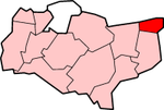
Thanet District
| Thanet District | |
|---|---|
 Location in Kent |
|
| status | District |
| region | South East England |
| Administration County | Kent |
| Administrative headquarters | Margate |
| surface | 103.30 km² (241.) |
| Residents | 129,200 (152.) |
| ONS code | 29UN |
| Website | www.thanet.gov.uk |
Thanet is a district in Kent in England . It covers an area on the Thames estuary known as the Isle of Thanet . The administrative seat is in Margate ; other significant locations are Birchington-on-Sea , Broadstairs , Manston , Ramsgate and Westgate-on-Sea .
The district was formed on April 1, 1974 and was created from the merger of the municipal boroughs Margate and Ramsgate, the urban district of Broadstairs and St Peter's and part of the rural district of Eastry.
Coordinates: 51 ° 22 ′ N , 1 ° 23 ′ E