Corby
| Corby | ||
|---|---|---|
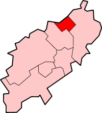
| Location in Northamptonshire | ||
| Coordinates | 52 ° 29 ′ N , 0 ° 42 ′ W | |
|
|
||
| Residents | 53,500 (as of 2007) | |
| surface | 80.28 km² (31 mi² ) | |
| Population density | 666.4 inhabitants / km² | |
| administration | ||
| Post town | CORBY | |
| ZIP code section | NN17-18 | |
| prefix | 01536 | |
| Part of the country | England | |
| Shire county | Northamptonshire | |
| District | Corby | |
| ONS code | 34UB | |
| Website: www.corby.gov.uk | ||
Corby is an industrial town about 14 kilometers north of Kettering in Northamptonshire , England . The city has about 55,000 inhabitants, has borough status and forms a district of Northamptonshire. In 1950 Corby became one of the English New Towns .
In 1931 Corby was a small village with about 1500 inhabitants before the Stewards & Loyds (later British Steel ) steelworks settled there in the mid-1930s, attracting many workers from Scotland and Ireland. That is why many people in Corby still speak with a Scottish accent. The steel mill became the second largest of its kind in Europe and the population of Corby grew rapidly.
After 1980, however, the steel industry lost its importance and the plant had to be closed in 1981. A branch of the food company Weetabix is at this point today. There you will also find the Rockingham Motor Speedway , an elliptical circuit, the only one of its kind in Great Britain, where a Ford Cosworth set the speed record of 210 mph. In a court case it was confirmed that the Corby contaminated site had caused embryonic development damage.
There is a crater on Mars that bears the city's name.
Not far from Corby in Deene is Deene Park, a 14th century mansion that has been expanded several times.
Town twinning
- Velbert (Germany; since 1965)
- Châtellerault (France; since 1979)
Sons and daughters (selection)
- Emma Kennedy (* 1967), British author and actress
Web links
- Side of town
- about Corby at the BBC (English)


