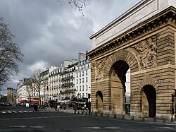
Boulevard Saint-Denis
| Boulevard Saint-Denis | |
|---|---|
| location | |
| Arrondissement | 2nd , 3rd , 10th |
| quarter | Bonne-Nouvelle Arts-et-Métiers Porte-Saint-Denis Porte-Saint-Matin |
| Beginning | 359, Rue Saint-Martin 1, Rue du Faubourg-Saint-Martin |
| The End | 252, Rue Saint-Denis 2, Rue du Faubourg-Saint-Denis |
| morphology | |
| length | 210 m |
| width | 37 m |
| history | |
| Emergence | 1670-1676 |
| Original names | Boulevard Franciade |
| Coding | |
| Paris | 8806 |
The Boulevard Saint-Denis [ bulvaʁ sɛ̃ de'ni ] is 210 meters long and the smallest of the Grands Boulevards on the Rive Droite . It borders the 2nd and 3rd arrondissements in the south and the 10th arrondissement in the north .
Location and access
It is part of the Grands Boulevards that run from west to east around the core of Paris: Boulevard de la Madeleine , Boulevard des Capucines , Boulevard des Italiens , Boulevard Montmartre , Boulevard Poissonnière , Boulevard Bonne-Nouvelle , Boulevard Saint-Denis, Boulevard Saint -Martin , Boulevard du Temple , Boulevard des Filles-du-Calvaire and Boulevard Beaumarchais .
Accordingly, a section of the Grands Boulevards lies between the Porte Saint-Martin and the Porte Saint-Denis . The Métro station Strasbourg - Saint-Denis is also located here .
Name origin
The boulevard takes its name from the nearby Rue Saint-Denis , which in turn owes its name to the fact that it led directly from the Pont au Change ( German money changer bridge ) to the city of Saint-Denis , where the necropolis of the kings of France is located .
history
Plan de Turgot - Rue Neuve d'Orléans (today: Boulevard Saint-Denis) with the two city gates; 1739
Boulevard Saint-Denis - The funeral of Adolphe Thiers on September 15, 1877
The decrees of June 7, 1670 and March 11, 1671 provided for the construction of large-scale boulevards after the Paris city walls were torn down . The 37 meter wide boulevard Saint-Denis was completed after a concession granted in July 1676. In the Plan de Turgot of 1739 it was still called "rue Neuve d'Orléans", on the city maps from 1760 and 1771 it had no name. During the French Revolution between 1789 and 1799 it was called "boulevard Franciade". It has since been named after the Porte Saint-Denis, a preserved gate from the former city wall. The complete demolition of this city wall took place by 1828. The boulevard Saint-Denis was on a small hill, so that in 1828 a leveling made for better navigability with horse-drawn vehicles on the initially 10 meter wide boulevard. Its widening to today's 37 meters is due to an order of May 6, 1836. House numbers have existed here since March 15, 1883.
Buildings
The Porte Saint-Denis was built in 1672 by François Blondel in memory of the conquests of Louis XIV in the Dutch War (1672–1678) and on the Lower Rhine (1672–1678), which were ended by the Peace of Nijmegen . The bas-relief above the archway represents a crossing of the Rhine. The Porte Saint-Martin at the other end of the street was built in 1674, also in honor of King Louis XIV, in memory of his victories in Franche-Comté during the Dutch War. It was built by Pierre Bullet , a student of Blondel. The entrance to the Passage du Prado , which was built in 1830, is at nos. 18-20 .
Web links
Individual evidence
- ↑ Louis Nicolas Bescherelle / G. Devars, Grand dictionnaire de géographie universelle ancienne et moderne , Volume 4, 1859, p. 172
- ^ A b Félix and Louis Lazare, Dictionnaire administratif et historique des rues et monuments de Paris , 1855, p. 310
Coordinates: 48 ° 52 ′ 11.4 " N , 2 ° 21 ′ 11.3" E


