
Bourneville (yours)
| Bourneville | ||
|---|---|---|
|
||
| local community | Bourneville-Sainte-Croix | |
| region | Normandy | |
| Department | Your | |
| Arrondissement | Bernay | |
| Coordinates | 49 ° 24 ' N , 0 ° 37' E | |
| Post Code | 27500 | |
| Former INSEE code | 27107 | |
| Incorporation | January 1, 2016 | |
| status | Commune déléguée | |
 Bourneville Town Hall (Mairie) |
||

Bourneville is a village and a commune déléguée in the commune of Bourneville-Sainte-Croix with 1,004 inhabitants (as of January 1, 2017) in Normandy (before 2016 Haute-Normandie ) in France . The inhabitants are called Bournevillais . The administrative center of the municipality of Bourneville-Sainte-Croix is located in Bourneville.
On January 1, 2016, Bourneville was merged with Sainte-Croix-sur-Aizier to form the Commune nouvelle Bourneville-Sainte-Croix . The municipality of Bourneville was part of the Eure department , the Bernay arrondissement and the Bourg-Achard canton ( Quillebeuf-sur-Seine until 2015 ).
geography
Bourneville is about 50 kilometers east-southeast of Le Havre . To the south of the village is the motorway triangle of the Autoroute A13 with the Autoroute A131 .
Population development
| year | 1962 | 1968 | 1975 | 1982 | 1990 | 1999 | 2006 | 2013 |
|---|---|---|---|---|---|---|---|---|
| Residents | 505 | 461 | 591 | 680 | 691 | 736 | 827 | 975 |
| Source: Cassini and INSEE | ||||||||
Attractions
- Church Saint-Pierre
- Beaumont manor, monument historique since 1996

Saint-Pierre church
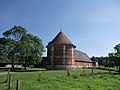
Beaumont manor pigeon tower

