
Bourneville-Sainte-Croix
| Bourneville-Sainte-Croix | ||
|---|---|---|
|
||
| region | Normandy | |
| Department | Your | |
| Arrondissement | Bernay | |
| Canton | Bourg-Achard | |
| Community association | Roumois Seine | |
| Coordinates | 49 ° 24 ' N , 0 ° 37' E | |
| height | 35-137 m | |
| surface | 15.83 km 2 | |
| Residents | 1,291 (January 1, 2017) | |
| Population density | 82 inhabitants / km 2 | |
| Post Code | 27500 | |
| INSEE code | 27107 | |

Bourneville-Sainte-Croix is a French commune with 1,291 inhabitants (as of January 1 2017) in the department of Eure in the region of Normandy . It belongs to the Arrondissement of Bernay and the canton of Bourg-Achard and is a member of the Roumois Seine municipality .
geography
Bourneville-Sainte-Croix is about 50 kilometers east-southeast of Le Havre . Mesnils-sur-Iton is surrounded by the neighboring communities of Tocqueville and Aizier in the north, Vatteville-la-Rue in the north-east, Étréville in the east and south-east, Valletot in the south, Le Perrey in the south-west and Trouville-la-Haule in the west and north-west.
In the south of the municipality is the motorway triangle of the A13 autoroute with the A131 autoroute .
history
On January 1, 2016, the previously independent communes of Bourneville and Sainte-Croix-sur-Aizier were merged to form the new commune ( Commune nouvelle ) Bourneville-Sainte-Croix. The seat of this newly created local authority is in the district of Bourneville.
structure
| District | former INSEE code |
Area (km²) | Population (2016) |
|---|---|---|---|
| Bourneville (administrative headquarters) | 27107 | 11.01 | 987 |
| Sainte-Croix-sur-Aizier | 27526 | 4.82 | 282 |
Attractions
Bourneville
- Saint-Pierre church
- Beaumont manor, monument historique since 1996
Sainte-Croix-sur-Aizier
- Sainte-Croix church from the 14th century with alterations from the 16th / 17th century. century

Saint-Pierre church in Bourneville

Sainte-Croix church in Sainte-Croix-sur-Aizier
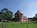
Beaumont manor pigeon tower


Web links
Individual evidence
- ↑ Population figures retrospectively from January 1, 2016