Boissey-le-Châtel
| Boissey-le-Châtel | ||
|---|---|---|

|
|
|
| region | Normandy | |
| Department | Your | |
| Arrondissement | Bernay | |
| Canton | Bourgtheroulde-Infreville | |
| Community association | Roumois Seine | |
| Coordinates | 49 ° 16 ' N , 0 ° 47' E | |
| height | 87-156 m | |
| surface | 4.38 km 2 | |
| Residents | 880 (January 1, 2017) | |
| Population density | 201 inhabitants / km 2 | |
| Post Code | 27520 | |
| INSEE code | 27077 | |
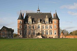
 Tilly Castle |
||
Boissey-le-Chatel is a French commune with 880 inhabitants (at January 1, 2017) in the Eure in the region of Normandy . It belongs to the Arrondissement of Bernay and the canton of Bourgtheroulde-Infreville .
history
Boissey-le-Châtel is located on a former junction of the Roman road from Lisieux (Noviomagus Lexoviorum) via Brionne (Breviodurum) to Rouen (Rotomagus) . This route led via Lieurey and Pont-Authou to La Bouille ( Département Seine-Maritime ). In 1911 the foundations of a Gallo-Roman villa were found in the lieu-dit ('place that is called ..') Mare-aux-Loups, about 300 meters from Tilly Castle .
On August 26, 1944, Boissy-le-Châtel was liberated in World War II (1939-1945) by the 5th Royal Inniskilling Dragoon Guards and the 7th Armored Division of the British Army . The Wehrmacht offered resistance. Six liberators died. A memorial plaque was erected for two of them, and a street was named after another.
Population development
| year | 1962 | 1968 | 1975 | 1982 | 1990 | 1999 | 2008 | 2016 |
| Residents | 511 | 533 | 601 | 700 | 674 | 687 | 845 | 897 |
Attractions
Tilly Castle was built between 1530 and 1535. It is classified as ( Monument historique ).
The Butte du Diable is the ruin of a medieval moth that stands within a rectangular area with a side length of 125 × 75 meters. The area is surrounded by a wall and a moat.
economy
Protected Geographical Indications (IGP) apply to pork (Porc de Normandie) , poultry (Volailles de Normandie) and cider (Cidre de Normandie and Cidre normand) in the municipality .
Web links
Individual evidence
- ^ A b Dominique Cliquet: L'Eure . 27. In: Michel Provost, Academie des inscriptions et belles-lettres, Ministere de la culture (ed.): Carte Archéologique de la Gaule . Fondation Maison des Sciences de l'Homme, Paris 1993, ISBN 2-87754-018-9 , chap. 118 , p. 87 (French).
- ↑ Eddy Florentin: Guide des plages du Débarquement et de la Bataille de Normandie . Perrin, Caen 2003, ISBN 2-262-02024-8 , chap. 13 , p. 379 f . (French).
- ↑ Le village de Boissey-le-Châtel. In: Annuaire-Mairie.fr. Retrieved July 6, 2012 (French).

