
Le Bosc du Theil
| Le Bosc du Theil | ||
|---|---|---|
|
||
| region | Normandy | |
| Department | Your | |
| Arrondissement | Bernay | |
| Canton | Le Neubourg | |
| Community association | Pays du Neubourg | |
| Coordinates | 49 ° 14 ' N , 0 ° 51' E | |
| height | 102-159 m | |
| surface | 20.11 km 2 | |
| Residents | 1,344 (January 1, 2017) | |
| Population density | 67 inhabitants / km 2 | |
| Post Code | 27370 | |
| INSEE code | 27302 | |
_mairie.JPG) Town hall of Le Bosc du Theil |
||

Le Bosc du Theil is a French commune with 1,344 inhabitants (at January 1, 2017) in the department of Eure in the region of Normandy . It belongs to the Arrondissement of Bernay and the canton of Le Neubourg and is a member of the Roumois Seine municipality .
geography
Le Bosc du Theil is about 30 kilometers southwest of Rouen . Le Bosc du Theil is surrounded by the neighboring communities Les Monts du Roumois in the north, La Haye-du-Theil in the east and northeast, Saint-Meslin-du-Bosc in the east, La Pyle and Le Troncq in the southeast, Épégard in the south, La Neuville-du-Bosc to the west and south-west, Saint-Paul-de-Fourques to the west and Saint-Éloi-de-Fourques to the north-west.
history
On January 1, 2016, the previously independent municipalities of Le Gros-Theil and Saint-Nicolas-du-Bosc were merged to form the new municipality ( commune nouvelle ) Le Bosc du Theil. The seat of this newly created regional authority is in the district of Le Gros-Theil.
structure
| District | former INSEE code |
Area (km²) | Population (2016) |
|---|---|---|---|
| Le Gros-Theil (administrative headquarters) | 27302 | 10.87 | 1,059 |
| Saint-Nicolas-du-Bosc | 27574 | 9.24 | 304 |
Attractions
Le Gros-Theil
- Saint-Georges church from the 15th century
Saint-Nicolas-du-Bosc
- Saint-Nicolas church

Saint-Georges church
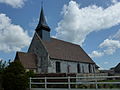
Saint-Nicolas church
_%C3%A9glise_(01).JPG)
_%C3%A9glise_St.Nicolas.JPG)
Personalities
- Gaston Lenôtre (1920–2009), pastry chef, born in Saint-Nicolas-du-Bosc
Web links
Individual evidence
- ↑ Population figures retrospectively from January 1, 2016