
Saint-Etienne-l'Allier
| Saint-Etienne-l'Allier | ||
|---|---|---|
|
||
| region | Normandy | |
| Department | Your | |
| Arrondissement | Bernay | |
| Canton | Beuzeville | |
| Community association | Lieuvin Pays d'Auge | |
| Coordinates | 49 ° 16 ' N , 0 ° 33' E | |
| height | 85-166 m | |
| surface | 11.32 km 2 | |
| Residents | 547 (January 1, 2017) | |
| Population density | 48 inhabitants / km 2 | |
| Post Code | 27450 | |
| INSEE code | 27538 | |
| Website | http://www.saintetiennelallier.fr/public/ | |
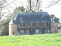
 Town hall (Mairie) of Saint-Étienne-l'Allier |
||

Saint-Etienne-l'Allier is a French municipality with 547 inhabitants (as of January 1 2017) in the Eure in the region Normandy (before 2016 Haute-Normandie ). It belongs to the canton of Beuzeville ( Saint-Georges-du-Vièvre until 2015 ). The inhabitants are called Stéphanois .
geography
Saint-Étienne-l'Allier is located about 34 kilometers north-northwest of Bernay in the Lieuvin . Saint-Étienne-l'Allier is surrounded by the neighboring communities of Saint-Martin-Saint-Firmin in the north, Saint-Christophe-sur-Condé in the northeast, Saint-Pierre-des-Ifs in the east, and Saint-Georges-du-Vièvre in the South and south-east, La Poterie-Mathieu in the west and south-west, La Noë-Poulain in the west and Saint-Siméon in the north-west.
| year | 1793 | 1806 | 1856 | 1886 | 1901 | 1954 | 1962 | 1968 | 1975 | 1982 | 1990 | 1999 | 2006 | 2013 |
|---|---|---|---|---|---|---|---|---|---|---|---|---|---|---|
| Residents | 1,173 | 1,139 | 1,167 | 669 | 517 | 372 | 358 | 351 | 354 | 378 | 436 | 385 | 445 | 560 |
Attractions
- Saint-Étienne church from the 12th / 13th centuries Century, monument historique since 1996
- Le Vièvre mansion from the 16th century, monument historique since 1994

Saint-Etienne church
Le Vièvre manor house

