Le Plessis-Sainte-Opportune
| Le Plessis-Sainte-Opportune | ||
|---|---|---|
|
|
||
| region | Normandy | |
| Department | Your | |
| Arrondissement | Bernay | |
| Canton | Brionne | |
| Community association | Intercom Bernay Terres de Normandie | |
| Coordinates | 49 ° 4 ′ N , 0 ° 52 ′ E | |
| height | 140-159 m | |
| surface | 11.37 km 2 | |
| Residents | 335 (January 1, 2017) | |
| Population density | 29 inhabitants / km 2 | |
| Post Code | 27170 | |
| INSEE code | 27466 | |
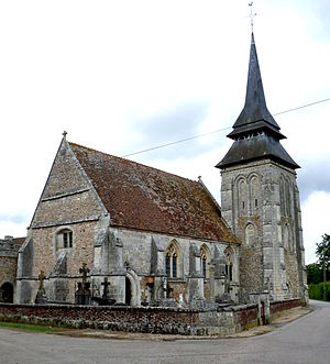
 Le Plessis - Église Saint-André |
||
Le Plessis-Sainte-Opportune is a French commune with 1,225 inhabitants (as of January 1 2017) in the Eure in the region of Normandy . The community consisting of several hamlets (hameaux) and individual farms (fermes) was only created in 1846 when the communities of Sainte-Opportune-la-Campagne and Plessis-Mahiet were merged .
location
Le Plessis-Sainte-Opportune is located in Haute-Normandie about 25 km (driving distance) northwest of Évreux at an altitude of approx. 153 m. The frost-free climate is largely dependent on the sea, i. H. influenced by the English Channel ; Rain (approx. 770 mm / year) falls throughout the year.
Population development
| year | 1851 | 1901 | 1954 | 1999 | 2017 |
| Residents | 457 | 291 | 234 | 252 | 1225 |
The continual population decline in the 20th century is essentially due to the mechanization of agriculture and the associated loss of jobs.
economy
Agriculture, which in earlier times was mainly self-sufficient , forms the basis of community life.
history
The church of Le Plessis was once a priory church of the Abbey of Le Bec Helloin .
Attractions
- The Gothic Église Saint-André in Le Plessis, built largely from flint boulders, dates back to the 14th century and was once a priory church of Le Bec Abbey ; However, the windows were enlarged in the 16th century and late Gothic Flamboyant - tracery provided. The bell tower (clocher) is a remnant of a previous Romanesque building from the 13th century. The predominantly of brick masonry apse seems to have originated in the 18th century. The furnishings include several statues and a carved altar structure from the 17th century. Church construction has been recognized as a monument historique since 1921 .
- The Église Sainte-Opportune was built in the 13th century, but redesigned several times in later times. The church building, threatened by collapse, has a shallowly closing apse and has been recognized as a monument historique since 1961 .
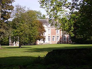
- The Château Saint-Léger originally dates from the 12th century; However, it was converted into a palace complex between the 17th and 19th centuries and has been recognized as a monument historique since 1976 .
- Other buildings are also partially registered in the monument register; these include the church of Saint-Pierre in La Huanière , a manor house (former priory) from the 15th century in Le Plessis as well as a medieval fortification in Bruyères-de-Tiron and a manor house from the 18th century in Chesnay .
Web links
Individual evidence
- ↑ Le Plessis-Sainte-Opportune - map with altitude information
- ↑ Le Plessis-Sainte-Opportune - climate tables
- ↑ Le Plessis-Sainte-Opportune - Saint-André church in the Base Mérimée of the French Ministry of Culture (French)
- ↑ Le Plessis-Sainte-Opportune - Saint-André Church
- ↑ Le Plessis-Sainte-Opportune - Saint-André Church
- ↑ Le Plessis-Sainte-Opportune - Church of Sainte-Opportune in the Base Mérimée of the French Ministry of Culture (French)
- ↑ Le Plessis-Sainte-Opportune - Church of Sainte-Opportune
- ↑ Le Plessis-Sainte-Opportune - Château Saint-Léger in the Base Mérimée of the French Ministry of Culture (French)

