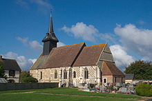
Le Lesme
| Le Lesme | ||
|---|---|---|
|
|
||
| region | Normandy | |
| Department | Your | |
| Arrondissement | Bernay | |
| Canton | Breteuil | |
| Community association | Interco Normandie Sud Eure | |
| Coordinates | 48 ° 54 ' N , 0 ° 51' E | |
| height | 149-193 m | |
| surface | 26.5 km 2 | |
| Residents | 669 (January 1, 2017) | |
| Population density | 25 inhabitants / km 2 | |
| Post Code | 27160 | |
| INSEE code | 27565 | |
Le Lesme is a French municipality with 669 inhabitants (as of January 1 2017) in the Eure in the region of Normandy ; it belongs to the Arrondissement Bernay (until 2017 Évreux ) and the canton Breteuil .
On January 1, 2016, Le Lesme was formed as Commune nouvelle from the communes of Sainte-Marguerite-de-l'Autel and Guernanville .
geography
Le Lesme is about 29 kilometers west-southwest of Évreux . Le Lesme is surrounded by the neighboring communities of Le Fidelaire in the north and west, Sainte-Marthe in the northeast, Beaubray in the east, Saint-Denis-du-Béhélan in the southeast, Breteuil in the south and southeast and Les Baux-de-Breteuil in the west and southwest .
structure
| District | former INSEE code |
Area (km²) | Population (2017) |
|---|---|---|---|
| Sainte-Marguerite-de-l'Autel (administrative headquarters) | 27565 | 23.27 | 567 |
| Guernanville | 27303 | 3.23 | 102 |
Attractions
- Church of Sainte-Marguerite in Sainte-Marguerite-de-l'Autel, Monument historique
Web links
Commons : Le Lesme - collection of images, videos and audio files

