
Barquet
| Barquet | ||
|---|---|---|
|
||
| region | Normandy | |
| Department | Your | |
| Arrondissement | Bernay | |
| Canton | Brionne | |
| Community association | Intercom Bernay Terres de Normandie | |
| Coordinates | 49 ° 3 ' N , 0 ° 52' E | |
| height | 101-161 m | |
| surface | 13.68 km 2 | |
| Residents | 449 (January 1, 2017) | |
| Population density | 33 inhabitants / km 2 | |
| Post Code | 27170 | |
| INSEE code | 27040 | |
_mairie.JPG) Town Hall (Mairie) of Barquet |
||

Barquet is a commune with 449 inhabitants (at January 1, 2017) in the Eure in the region Normandy (before 2016 Haute-Normandie ). It belongs to the arrondissement of Bernay and the canton of Brionne (until 2015 Beaumont-le-Roger ).
geography
Barquet is located about 22 kilometers west-northwest of Évreux on the Risle , which borders the municipality in the west. Barquet is surrounded by the neighboring communities of Le Plessis-Sainte-Opportune in the north and northeast, Émanville in the east, Berville-la-Campagne in the southeast, Romilly-la-Puthenaye in the south and Grosley-sur-Risle in the west and north-west.
Population development
| year | 1962 | 1968 | 1975 | 1982 | 1990 | 1999 | 2006 | 2013 |
| Residents | 320 | 302 | 295 | 316 | 289 | 359 | 343 | 431 |
| Source: Cassini and INSEE | ||||||||
Attractions
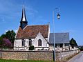
- Saint-Jean-Baptiste church from the 16th / 17th centuries Century, Monument historique since 1965
- Saint-Pierre church from the 16th / 17th centuries century
- Saint-Martin church in Le Bosc-Roger from the 16th century
- La Vacherie Castle, monument historique since 1931
- 18th century mansion

Saint-Jean-Baptiste church
Saint-Pierre church
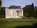
La Vacherie Castle
_%C3%A9glise_Saint-Jean-Baptiste_de_la_Vacherie.JPG)
_%C3%A9glise_Saint-Pierre.JPG)

Web links
Commons : Barquet - collection of images, videos and audio files