
Graveron-Sémerville
| Graveron-Sémerville | ||
|---|---|---|
|
||
| region | Normandy | |
| Department | Your | |
| Arrondissement | Evreux | |
| Canton | Le Neubourg | |
| Community association | Pays du Neubourg | |
| Coordinates | 49 ° 6 ′ N , 0 ° 59 ′ E | |
| height | 133-149 m | |
| surface | 8.03 km 2 | |
| Residents | 303 (January 1, 2017) | |
| Population density | 38 inhabitants / km 2 | |
| Post Code | 27110 | |
| INSEE code | 27298 | |
_mairie.JPG) Town hall (Mairie) of Graveron-Sémerville |
||

Graveron-Sémerville is a French municipality with 303 inhabitants (at January 1, 2017) in the department of Eure in the region Normandy (before 2016 Haute-Normandie ); it belongs to the Arrondissement Bernay (until 2017 Évreux ) and the canton Le Neubourg (until 2015 Évreux-Nord ). The inhabitants call themselves Graveron-Sémervillais .
geography
Graveron-Sémerville is about seventeen kilometers northwest of Évreux . Graveron-Sémerville is surrounded by the neighboring communities of Saint-Aubin-d'Écrosville in the north and northeast, Quittebeuf in the east and northeast, Tournedos-Bois-Hubert in the east and southeast, Ormes in the south, Le Tilleul-Lambert in the southwest and Sainte-Colombe -la-Commanderie to the west and northwest.
history
| year | 1793 | 1846 | 1881 | 1936 | 1962 | 1968 | 1975 | 1982 | 1990 | 1999 | 2006 | 2013 |
|---|---|---|---|---|---|---|---|---|---|---|---|---|
| Residents | 62 | 228 | 195 | 194 | 166 | 173 | 158 | 243 | 240 | 266 | 289 | 295 |
Attractions
- Saint Barthélemy church from the 17th century
- Saint-Jubin chapel from 1760
- Graveron Castle from the 17th century, monument historique since 1996
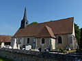
Saint Barthélemy Church

Graveron Castle
_%C3%A9glise_Saint-Barth%C3%A9lemy_de_Graveron.JPG)

sons and daughters of the town
- Narcisse-Achille de Salvandy (1795–1856), diplomat, politician and writer
Individual evidence
- ↑ Graveron-Sémerville on Cassini.ehess.fr (French). Retrieved December 17, 2017.