
Fatouville-Grestain
| Fatouville-Grestain | ||
|---|---|---|
|
||
| region | Normandy | |
| Department | Your | |
| Arrondissement | Bernay | |
| Canton | Beuzeville | |
| Community association | Pays de Honfleur-Beuzeville | |
| Coordinates | 49 ° 24 ' N , 0 ° 20' E | |
| height | 0-112 m | |
| surface | 10.26 km 2 | |
| Residents | 746 (January 1, 2017) | |
| Population density | 73 inhabitants / km 2 | |
| Post Code | 27210 | |
| INSEE code | 27233 | |

Fatouville-Grestain is a French municipality with 746 inhabitants (as of January 1 2017) in the department of Eure in the region of Normandy . It belongs to the Bernay arrondissement and is part of the canton of Beuzeville . The inhabitants are called Fatouvillais .
geography
Fatouville-Grestain is located about 15 kilometers east-southeast of Le Havre on the Seine , which borders the municipality in the north. Fatouville-Grestain is surrounded by the neighboring communities of Saint-Vigor-d'Ymonville in the north, Berville-sur-Mer in the northeast, Saint-Pierre-du-Val in the south and east and Fiquefleur-Équainville in the south and west.
Population development
| 1962 | 1968 | 1975 | 1982 | 1990 | 1999 | 2006 | 2013 |
|---|---|---|---|---|---|---|---|
| 434 | 361 | 406 | 494 | 507 | 536 | 669 | 761 |
| Source: Cassini and INSEE | |||||||
Attractions
- Saint-Martin church from the 12th / 13th centuries Century, Monument historique since 1954
- Chapel of Saint Martin in Carbec
- Rectory in Carbec
- Former Notre-Dame de Grestain monastery , founded around 1040, destroyed in 1766, monument historique since 1975
- La Pommeraye mansion
- Le Feugré manor house
- Fatouville lighthouse from the 19th century, monument historique since 2011
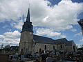
Saint Martin Church

Chapel of Saint Martin in Carbec

Remains of the monastery of Grestain

Fatouville lighthouse


