
Chaise-Dieu-du-Theil
| Chaise-Dieu-du-Theil | ||
|---|---|---|
|
||
| region | Normandy | |
| Department | Your | |
| Arrondissement | Bernay | |
| Canton | Breteuil | |
| Community association | Interco Normandie Sud Eure | |
| Coordinates | 48 ° 46 ' N , 0 ° 46' E | |
| height | 187-219 m | |
| surface | 5.93 km 2 | |
| Residents | 216 (January 1, 2017) | |
| Population density | 36 inhabitants / km 2 | |
| Post Code | 27580 | |
| INSEE code | 27137 | |
| Website | http://chaisedieudutheil.fr/ | |
 Town hall (Mairie) of Chaise-Dieu-du-Theil |
||

Chaise-Dieu-du-Theil is a French municipality with 216 inhabitants (at January 1, 2017) in the Eure in the region Normandy (before 2016 Haute-Normandie ); it belongs to the Arrondissement of Bernay and the canton of Breteuil (until 2015 Rugles ). The inhabitants are called Casadéens .
geography
Chaise-Dieu-du-Theil is about 38 kilometers southwest of Evreux on the Iton . Chaise-Dieu-du-Theil is surrounded by the neighboring communities of Chéronvilliers in the north, Bourth in the east, Gournay-le-Guérin in the south, Chandai in the west and south-west and Saint-Sulpice-sur-Risle in the north-west.
Population development
| year | 1962 | 1968 | 1975 | 1982 | 1990 | 1999 | 2006 | 2013 |
| Residents | 304 | 295 | 273 | 252 | 241 | 245 | 234 | 238 |
| Source: Cassini and INSEE | ||||||||
Attractions
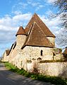
- Notre-Dame church
- Chaise-Dieu Monastery, also: Fontevrault Priory, built in the 11th / 12th. Century, alterations from 16./17. Century, since 1971 Monument historique
- Le Theil Priory
- Rectory
- Saint-Jean chapel
- Mill
- Courteilles Castle

Notre-Dame church
monastery


Web links
Commons : Chaise-Dieu-du-Theil - collection of pictures, videos and audio files