
Sainte-Opportune-du-Bosc
| Sainte-Opportune-du-Bosc | ||
|---|---|---|
|
||
| region | Normandy | |
| Department | Your | |
| Arrondissement | Bernay | |
| Canton | Brionne | |
| Community association | Pays du Neubourg | |
| Coordinates | 49 ° 10 ′ N , 0 ° 50 ′ E | |
| height | 97-150 m | |
| surface | 8.07 km 2 | |
| Residents | 648 (January 1, 2017) | |
| Population density | 80 inhabitants / km 2 | |
| Post Code | 27110 | |
| INSEE code | 27576 | |
| Website | http://www.sainte-opportune-du-bosc.fr/ | |
_mairie.JPG) Town hall (Mairie) of Sainte-Opportune-du-Bosc |
||

Sainte-Opportune-du-Bosc is a French municipality with 648 inhabitants (as of January 1 2017) in the Eure in the region Normandy (before 2016 Haute-Normandie ). It belongs to the arrondissement of Bernay and the canton of Brionne (until 2015 Beaumont-le-Roger ).
geography
Sainte-Opportune-du-Bosc is located about 27 kilometers northwest of Évreux . Sainte-Opportune-du-Bosc is surrounded by the neighboring communities of La Neuville-du-Bosc in the north and northwest, Épégard in the northeast, Vitot in the east, Le Neubourg in the southeast, Villez-sur-le-Neubourg in the south and southeast, Rouge Perriers in the south, Thibouville in the southwest and Harcourt in the west.
Population development
| year | 1962 | 1968 | 1975 | 1982 | 1990 | 1999 | 2006 | 2013 |
| Residents | 148 | 145 | 141 | 192 | 278 | 334 | 563 | 668 |
| Source: Cassini and INSEE | ||||||||
Attractions
- Sainte-Opportune church from the 12th century, alterations from the 16th century
- Saint-Lubin Chapel in Le Bosc from the 12th century, monument historique since 1934
- Le Champ de Bataille castle from the 17th / 18th centuries Century, Monument historique since 1952/1971/1995, with park
- Manor house from the 17th / 18th centuries century
- Priory from the 12th century, alterations from the 18th century
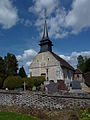
Sainte-Opportune church

Le Champ-de-Batille castle
_%C3%A9glise.JPG)

Web links
Commons : Sainte-Opportune-du-Bosc - Collection of images, videos and audio files