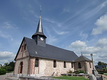
Saint-Ouen-de-Thouberville
| Saint-Ouen-de-Thouberville | ||
|---|---|---|
|
|
||
| region | Normandy | |
| Department | Your | |
| Arrondissement | Bernay | |
| Canton | Bourg-Achard | |
| Community association | Roumois Seine | |
| Coordinates | 49 ° 21 ' N , 0 ° 53' E | |
| height | 73-137 m | |
| surface | 6.32 km 2 | |
| Residents | 2,378 (January 1, 2017) | |
| Population density | 376 inhabitants / km 2 | |
| Post Code | 27310 | |
| INSEE code | 27580 | |
| Website | http://www.saintouendethouberville.com/ | |
Saint-Ouen-de-Thouberville is a French commune with 2,378 inhabitants (as of January 1 2017) in the department of Eure in the region of Normandy . It belongs to the arrondissement of Bernay and is part of the canton of Bourg-Achard (until 2015: canton of Routot ). The inhabitants are called Thoubervillais .
geography
Saint-Ouen-de-Thouberville is located about 20 kilometers southwest of Rouen in the Roumois countryside . Saint-Ouen-de-Thouberville is surrounded by the neighboring communities of La Trinité-de-Thouberville in the north, Caumont in the north and northeast, La Bouille in the northeast, Moulineaux in the east, Bourgtheroulde-Infreville in the south and Bosgouet in the west.
The A13 autoroute runs through the municipality .
Population development
| year | 1896 | 1926 | 1936 | 1954 | 1962 | 1968 | 1975 | 1982 | 1990 | 1999 | 2006 | 2017 |
| Residents | 764 | 626 | 650 | 825 | 1027 | 1189 | 1520 | 1524 | 1447 | 1725 | 2089 | 2378 |
| Sources: Cassini and INSEE | ||||||||||||
Attractions
- Saint-Ouen church
- Cemetery cross from the 16th century, monument historique since 1965
Web links
Commons : Saint-Ouen-de-Thouberville - Collection of images, videos and audio files

