
Saint-Léger-de-Rôtes
| Saint-Léger-de-Rôtes | ||
|---|---|---|
|
||
| region | Normandy | |
| Department | Your | |
| Arrondissement | Bernay | |
| Canton | Bernay | |
| Community association | Intercom Bernay Terres de Normandie | |
| Coordinates | 49 ° 7 ' N , 0 ° 39' E | |
| height | 104-154 m | |
| surface | 6.46 km 2 | |
| Residents | 436 (January 1, 2017) | |
| Population density | 67 inhabitants / km 2 | |
| Post Code | 27300 | |
| INSEE code | 27557 | |
| Website | http://www.saint-leger-de-rostes.com/ | |
_mairie.JPG) Town hall (Mairie) of Saint-Léger-de-Rôtes |
||

Saint-Leger-de-Red is a French municipality with 436 inhabitants (as of January 1 2017) in the Eure in the region of Normandy . It belongs to the Arrondissement of Bernay and the Canton of Bernay . The inhabitants are called Légerôtois .
geography
Saint-Léger-de-Rôtes lies on the border of the Pays d'Ouche and Lieuvin . Saint-Léger-de-Rôtes is surrounded by the neighboring communities of Plasnes in the north and north-west, Nassandres sur Risle in the north, Serquigny in the east, Fontaine-l'Abbé in the south and south-east, Menneval in the west and south-west and Valailles in the west and north-west.
| year | 1962 | 1968 | 1975 | 1982 | 1990 | 1999 | 2006 | 2013 |
|---|---|---|---|---|---|---|---|---|
| Residents | 317 | 354 | 405 | 444 | 465 | 426 | 421 | 403 |
Attractions
- Saint-Pierre church, historique monument since 1993
- Saint-Léger church, historic monument since 1993
- 18th century castle

Saint-Pierre church
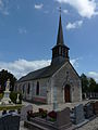
Saint-Léger church

lock
_%C3%A9glise_St-Pierre_de_R%C3%B4tes_MH.JPG)
_%C3%A9glise_Saint-Leger_MH.JPG)
_ch%C3%A2teau.JPG)
Web links
Commons : Saint-Léger-de-Rôtes - Collection of images, videos and audio files