Tourville-sur-Pont-Audemer
| Tourville-sur-Pont-Audemer | ||
|---|---|---|
|
|
||
| region | Normandy | |
| Department | Your | |
| Arrondissement | Bernay | |
| Canton | Pont-Audemer | |
| Community association | Pont-Audemer Val de Risle | |
| Coordinates | 49 ° 20 ' N , 0 ° 31' E | |
| height | 11-127 m | |
| surface | 10.8 km 2 | |
| Residents | 721 (January 1, 2017) | |
| Population density | 67 inhabitants / km 2 | |
| Post Code | 27500 | |
| INSEE code | 27655 | |
Tourville-sur-Pont-Audemer is a French municipality with 721 inhabitants (as of January 1 2017) in the Eure in the region of Normandy . The municipality belongs to the canton of Pont-Audemer .
geography
Tourville-sur-Pont-Audemer is located about 34 kilometers southeast of Le Havre in the Roumois . Tourville-sur-Pont-Audemer is surrounded by the neighboring communities of Pont-Audemer in the north, Campigny in the east, Saint-Siméon in the south, Selles in the southwest and Les Préaux in the west.
| year | 1962 | 1968 | 1975 | 1982 | 1990 | 1999 | 2006 | 2013 |
|---|---|---|---|---|---|---|---|---|
| Residents | 477 | 506 | 565 | 507 | 528 | 554 | 712 | 735 |
Culture and sights
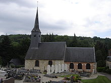
- Saint-Pierre church
Personalities
- Charles-Victor Langlois (1863–1929), historian and director of the French National Archives, buried in Tourville
Web links
Commons : Tourville-sur-Pont-Audemer - Collection of images, videos and audio files

