
Quittebeuf
| Quittebeuf | ||
|---|---|---|
|
||
| region | Normandy | |
| Department | Your | |
| Arrondissement | Bernay | |
| Canton | Le Neubourg | |
| Community association | Pays du Neubourg | |
| Coordinates | 49 ° 6 ′ N , 1 ° 1 ′ E | |
| height | 131-149 m | |
| surface | 13.45 km 2 | |
| Residents | 663 (January 1, 2017) | |
| Population density | 49 inhabitants / km 2 | |
| Post Code | 27110 | |
| INSEE code | 27486 | |
_mairie.JPG) Municipal administration (mairie) of Quittebeuf |
||

Quittebeuf (1801 still with the spelling Quitteboeuf ) is a French municipality with 663 inhabitants (at January 1, 2017) in the department of Eure in the region of Normandy . It belongs to the Bernay arrondissement and the Pays du Neubourg municipal association founded in 2000 .
geography
The municipality is located about 13 kilometers northwest of Évreux on the plateau of Le Neubourg between the river valleys of Eure , Risle and Seine . The area is characterized by the lack of surface running waters, which is due to the chalky subsoil. In the municipality there are a few small lakes with no outflow ( Mare Plate, Mare à Faux, Mare Blanque, Mare du Hom, Mare Cesse, Mare Quevillette, Mare Fessard, Mare Gondré, Le Routoir d'Ecambosc ). The 13.45 km² community area has almost no relief structures and is almost treeless. In addition to the village of Quittebeuf with the suburbs La Porte de Pierre and Le Bout de la Ville , the hamlets of Ecambosc, Le Bout d'Ambreville and Boslon also belong to the municipality of Quittebeuf. Neighboring municipalities are Écauville and Feuguerolles in the north, Bérengeville-la-Campagne in the east, Bacquepuis in the southeast, Bernienville in the south, Tournedos-Bois-Hubert in the southwest and Graveron-Sémerville in the west.
history
Around the year 1140 the village first appeared as Guitebe or Guitebef . It is believed that the place name is derived from the Germanic personal name Witto . The suffix -beuf is borrowed from the Nordic for both ( home village ).
Population development
| year | 1962 | 1968 | 1975 | 1982 | 1990 | 1999 | 2006 | 2016 | |
| Residents | 462 | 404 | 412 | 482 | 481 | 524 | 601 | 648 | |
| Sources: Cassini and INSEE | |||||||||
Attractions
- Saint-Pierre church, destroyed by fire in 1893 and rebuilt in 1896

Saint-Pierre church
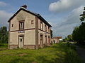
former Quittebeuf station
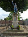
Fallen memorial
_%C3%A9glise,_vue_lat%C3%A9rale.JPG)

_monument_aux_morts.JPG)
Economy and Infrastructure
Quittebeuf is rural. There are seven farms in the municipality (cultivation of grain, pulses and oilseeds).
The municipality of Quittebeuf is located on the D 39 from Le Neubourg to Évreux . In Acquigny , 18 kilometers away, there is a connection to the motorway-like route nationale 154 . The nearest train station is in Évreux on the Mantes-la-Jolie – Cherbourg railway line .
supporting documents
- ↑ toponym on cassini.ehess.fr
- ↑ Dictionnaire des anciens noms de lieu du departement de l'Eure (French)
- ↑ Quittebeuf on cassini.ehess.fr
- ↑ Quittebeuf on insee.fr
- ↑ Farms on annuaire-mairie.fr (French)