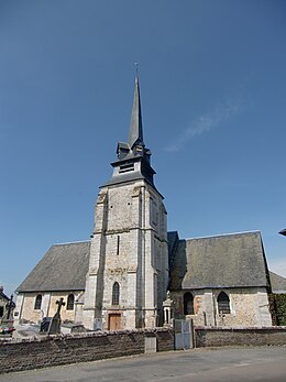
La Lande-Saint-Léger
| La Lande-Saint-Léger | ||
|---|---|---|
|
|
||
| region | Normandy | |
| Department | Your | |
| Arrondissement | Bernay | |
| Canton | Beuzeville | |
| Community association | Lieuvin Pays d'Auge | |
| Coordinates | 49 ° 18 ′ N , 0 ° 22 ′ E | |
| height | 38–152 m | |
| surface | 7.96 km 2 | |
| Residents | 368 (January 1, 2017) | |
| Population density | 46 inhabitants / km 2 | |
| Post Code | 27210 | |
| INSEE code | 27361 | |
La Lande-Saint-Léger is a French municipality with 368 inhabitants (as of January 1 2017) in the department of Eure in the region of Normandy . It belongs to the Bernay arrondissement and is part of the canton of Beuzeville . The inhabitants are called Landais .
geography
La Lande-Saint-Léger is located about 30 kilometers south-southeast of Le Havre in Lieuvin . La Lande-Saint-Léger is surrounded by the neighboring communities of Beuzeville in the north, Martainville in the east, Bonneville-la-Louvet in the south and south-east and Saint-André-d'Hébertot in the west.
Population development
| 1962 | 1968 | 1975 | 1982 | 1990 | 1999 | 2006 | 2013 |
|---|---|---|---|---|---|---|---|
| 179 | 222 | 198 | 164 | 201 | 208 | 269 | 322 |
| Source: Cassini and INSEE | |||||||
Attractions
- Saint-Léger church from the 12th century in Saint-Léger-sur-Bonneville
- 12th century Saint-Pierre church in La Lande
- Rectory from the 19th century
- 17th century manor house of Saint-Léger, monument historique since 1967
Web links
Commons : La Lande-Saint-Léger - Collection of images, videos and audio files

