Courbépine
| Courbépine | ||
|---|---|---|

|
|
|
| region | Normandy | |
| Department | Your | |
| Arrondissement | Bernay | |
| Canton | Bernay | |
| Community association | Intercom Bernay Terres de Normandie | |
| Coordinates | 49 ° 8 ′ N , 0 ° 34 ′ E | |
| height | 149-178 m | |
| surface | 11.91 km 2 | |
| Residents | 727 (January 1, 2017) | |
| Population density | 61 inhabitants / km 2 | |
| Post Code | 27300 | |
| INSEE code | 27179 | |
 Mairie |
||
Courbépine is a commune with 727 inhabitants (at January 1, 2017) in the Eure in the region of Normandy .
geography
Courbépine is located in Lieuvin , 51 kilometers southeast of Le Havre , 24 kilometers southeast of Lisieux and 6 kilometers north of Bernay , the capital of the arrondissement of the same name . Neighboring municipalities of Courbépine are Malouy in the northwest, Plasnes in the northeast, Valailles in the southeast and Saint-Martin-du-Tilleul in the southwest. The municipal area covers 1191 hectares, the mean height is 164 meters above sea level .
Courbépine is one of the municipalities in the Eure department where there is a risk of holes being suddenly formed several meters deep. The so-called Marnières are old marl pits that can open, for example, after heavy rain, when the debris is washed into the side passages. On average, there are around 15 underground cavities in the Eure department, especially Marnières and infiltration areas per square kilometer.
Courbépine is assigned to a type Cfb (according to Köppen and Geiger ) climate zone : warm, moderate rainy climate (C), fully humid (f), warmest month below 22 ° C, at least four months above 10 ° C (b). There is a maritime climate with a moderate summer.
history
In the vicinity of an old path of Rouen according Orbec the found archaeologist Le Metayer-Masselin ceramic fragments from Gallo-Roman times (52 v. Chr. To 486 n. Chr.).
The place name was first mentioned in a document around the year 1000 as Corbespina , and in 1025 as Curba Spina . The French Etymological Dictionary states that courbe-espina was the name of an apple variety in the Langue d'oïl of Normandy . The French word courbe means 'curve', courbé means ' curved'. Spina means 'thorn' in Latin and evolved into the French word épine .
In the Domesday Book of 1086 a Raoul de Courbespine is mentioned who was a tenant-in-chief in Kent . He was in dispute with the Archbishop of Canterbury , Lanfrank von Bec (around 1010 to 1089) over a piece of land on the Thames . Ordericus Vitalis (1075–1142) reported on a Chevalier named Roger de Courbépine, whose son Gilbert Maminot was bishop of Lisieux from 1077 to 1101 .
In the copy book of Le Bec Abbey there are several contracts for land donations or tithe claims in Courbépine from the 13th and 14th centuries. The Courbépine mill was first mentioned in a document in 1260. It was called le Moulin-Crespin and was then owned by the Abbey of Le Bec. In the Obituaire of the Church of Lisieux it is recorded that the Bishop of Lisieux Guillaume d'Estouteville I († 1414), a relative of Guillaume d'Estouteville , bequeathed Courbépine's tithe to the Church of Lisieux. Around 1455, the Notre-Dame de Bernay Abbey also owned property in Courbépine.
Léonor II. Goyon de Matignon († 1714), Bishop and Comte of Lisieux , had the Courbépine castle built in lieu-dit ('place that is named ...') on the foundations of a medieval castle after 1677 . The Marquis de Prie later bought it for his wife Jeanne-Agnès Berthelot de Pléneuf (1698–1727). The castle was destroyed in 1777. In 1869 nothing could be seen of the main building above ground. The castle and the outbuildings are easy to see on aerial photos from the 1990s.
| year | Residents |
|---|---|
| 1841 | 842 |
| 1876 | 720 |
| 1886 | 638 |
| 1896 | 545 |
| 1911 | 495 |
| 1936 | 366 |
| 1962 | 435 |
| 1982 | 576 |
| 1999 | 619 |
| 2009 | 688 |
| 2016 | 732 |
In 1793 Courbépine received in the course of the French Revolution (1789-1799) under the name Courbepine the status of a municipality and 1801 through the administrative reform under Napoleon Bonaparte (1769-1821) again under the name Courbepine the right to local self-government .
In the Franco-Prussian War (1870–1871), the population of Courbépine only armed themselves in January 1871. Before that, the community, like many other rural communities in the region, had not defended itself against the German invaders, who had therefore plundered unhindered.
During the Second World War (1939-1945) Courbépine was occupied by the German Wehrmacht in June 1940 . In the summer of 1944, during Operation Overlord, the Allied Air Force bombed the town. The church was damaged in the process.
Culture and sights
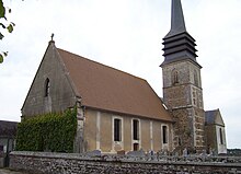
The patron saint of the Saint-Martin church is Martin of Tours . The bell tower was built in the 13th century. The choir and nave were renewed in 1680. In 1763 the church was restored. In 1999 the building was entered in the supplementary directory of the Monuments historiques ('historical monuments'). Two statues and a 17th century painting in the church were classified as a monument historique in 1907. The Roman Catholic Community de Courbépine belongs to the parish of Notre Dame de Charentonne of the Diocese of Évreux .
At the eastern entrance to the town there is a cross with the year 1724.
There are also several houses and farms from the 18th century in the municipality, whose walls are made of flint and sandstone . The roofs are covered with thatch or slate .
Economy and Infrastructure
In 2009, 15.9 percent of the workforce were employed in the municipality, the others are commuters . 4.9 percent of the employees were unemployed .
In the municipality, there are controlled designations of origin (AOC) for Pont-l'Évêque cheese , calvados and pommeau (Pommeau de Normandie) as well as Protected Geographical Indications (IGP) for pork (Porc de Normandie) , poultry (Volailles de Normandie) and cider ( Cider de Normandie and Cider normand) .
The municipal association Bernay et des environs (CCBE) founded an industrial and commercial area called Parc d'Activité des Granges in 2004 . It is located on the N138 route on an area of 80 hectares , in the municipal areas of Bernay, Courbépine and Menneval .
The nearest train station is in Bernay, the nearest airport is the Aéroport de Deauville - Normandie in Saint-Gatien-des-Bois . The highway 28 runs from east to west through the municipality, the Départementsstraße 613 (former national road 13 ) touches the municipality in the north and the Départementsstraße 834 runs from south to north.
The public school école primaire Ernest Anquetil is a preschool and elementary school . Around 95 children attend classes there. The secondary schools are in Bernay.
Personalities

- Jeanne-Agnès Berthelot de Pléneuf (1698–1727), Marquise of Plasnes and mistress of the French Prime Minister Louis IV. Henri de Bourbon, prince de Condé , lived in her castle in Courbépine until her death.
Web links
Individual evidence
- ↑ a b c d e Village de Courbépine. In: Annuaire-Mairie.fr. Retrieved July 4, 2012 (French).
- ↑ a b List of the Communes. (No longer available online.) In: eure.pref.gouv.fr. Préfecture Eure, archived from the original on April 27, 2013 ; Retrieved July 6, 2012 (French). Info: The archive link was inserted automatically and has not yet been checked. Please check the original and archive link according to the instructions and then remove this notice.
- ^ Dominique Cliquet: L'Eure . 27. In: Michel Provost, Academie des inscriptions et belles-lettres, Ministere de la culture (ed.): Carte Archéologique de la Gaule . Fondation Maison des Sciences de l'Homme, Paris 1993, ISBN 2-87754-018-9 , chap. 88 , p. 82 (French).
- ^ Léon Coutil (1856-1943): Archéologique gauloise . Canton de Brionne. In: Société libre d'agriculture, sciences, arts et belles-lettres de l'Eure (ed.): Recueil de la Société d'agriculture, sciences, arts et belles-lettres du département de l'Eure (= 7 ). tape 3 . Paul Hérissey, Évreux 1915, p. 133 (French, online ).
- ^ Ernest Nègre: Toponymie générale de la France . tape 2 . Librairie Droz, 1996, ISBN 2-600-00133-6 , pp. 1323 (French, limited preview in Google Book search).
- ↑ Auguste Le Prévost , Léopold Delisle , Louis Paulin Passy, Andrew Dickson White: Mémoires et notes de M. Auguste Le Prevost pour servir à l'histoire du département de l'Eure . Ed .: Société d'agriculture des belles-lettres, sciences et arts de L'Eure. tape 1 . Évreux 1869, p. 554 f . (French, online ).
- ↑ a b c Entry No. 27179 in the Base Mérimée of the French Ministry of Culture (French)
- ^ Jean-Noël Le Borgne, Véronique Le Borgne, Pascale Eudier, Annie Etienne: Archeologie Aérienne dans l'Eure . Ed .: Association Archéo 27. Page de Garde, Caudebec-les-Elbeuf 2002, ISBN 2-84340-230-1 , p. 74 .
- ↑ Courbépine - notice communal. In: Cassini.ehess.fr. Retrieved July 4, 2012 (French).
- ↑ Alex Gardin: La guerre de 1870–1871 à Bernay . Les Éditions Page de Garde, Saint-Aubin-les-Elbeuf 1997, ISBN 2-84340-037-6 , p. 60 (French, first edition: 1898, reprint).
- ↑ A.-V. de Walle: Évreux et l'Eure pendant la guerre . Charles Herissey, Évreux 2000, ISBN 2-914417-05-5 , pp. 176 + 179 (French, first edition: 1946).
- ↑ Entry No. 27179 in the Base Palissy of the French Ministry of Culture (French)
- ↑ Notre Dame de Charentonne. (No longer available online.) Diocèse d'Évreux, archived from the original on July 2, 2013 ; Retrieved August 11, 2012 (French). Info: The archive link was inserted automatically and has not yet been checked. Please check the original and archive link according to the instructions and then remove this notice.
- ↑ Commune: Courbépine 27179. Thème: Tous les thèmes. In: Insee.fr. Institut national de la statistique et des études économiques , accessed on July 6, 2012 (French).
- ↑ Courbépine. In: Les-Villes.fr. Retrieved July 6, 2012 (French).


