Saint-Pierre-du-Val
| Saint-Pierre-du-Val | ||
|---|---|---|

|
|
|
| region | Normandy | |
| Department | Your | |
| Arrondissement | Bernay | |
| Canton | Beuzeville | |
| Community association | Pays de Honfleur-Beuzeville | |
| Coordinates | 49 ° 24 ' N , 0 ° 22' E | |
| height | 18-118 m | |
| surface | 12.23 km 2 | |
| Residents | 572 (January 1, 2017) | |
| Population density | 47 inhabitants / km 2 | |
| Post Code | 27210 | |
| INSEE code | 27597 | |
| Website | http://www.saintpierreduval.fr/ | |
Saint-Pierre-du-Val is a French commune with a population of 572 (as at 1st January 2017) in the department of Eure in the region of Normandy . It belongs to the Bernay arrondissement and is part of the canton of Beuzeville . The inhabitants are called Saint-Pierrais .
geography
Saint-Pierre-du-Val is about 19 kilometers east-southeast of Le Havre . Saint-Pierre-du-Val is surrounded by the neighboring communities of Berville-sur-Mer in the north, Conteville in the north and northeast, Foulbec in the east, Boulleville in the southeast, Beuzeville in the south, Manneville-la-Raoult in the southwest, Fiquefleur-Équainville in the West and southwest and Fatouville-Grestain to the west and northwest.
Population development
| 1962 | 1968 | 1975 | 1982 | 1990 | 1999 | 2006 | 2013 |
|---|---|---|---|---|---|---|---|
| 377 | 359 | 320 | 337 | 349 | 456 | 506 | 563 |
| Source: Cassini and INSEE | |||||||
Attractions
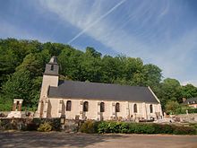
- Saint-Pierre church from the 12th century, alterations from the 17th century
- Notre-Dame church in Notre-Dame-du-Val from the 11th / 12th centuries century
- 13th century Saint-Etienne chapel in Le Mesnil, part of the Grestain Convent (in Fatouville-Grestain)
- Rectory
- Remains of the Saint-Pierre castle from the 11th century, almost razed in the Hundred Years War, in the 18th / 19th century. It was rebuilt as a castle in the 19th century
Web links
Commons : Saint-Pierre-du-Val - Collection of images, videos and audio files

