
Bouquelon
| Bouquelon | ||
|---|---|---|
|
||
| region | Normandy | |
| Department | Your | |
| Arrondissement | Bernay | |
| Canton | Bourg-Achard | |
| Community association | Pont-Audemer Val de Risle | |
| Coordinates | 49 ° 24 ' N , 0 ° 30' E | |
| height | 1–121 m | |
| surface | 11.71 km 2 | |
| Residents | 512 (January 1, 2017) | |
| Population density | 44 inhabitants / km 2 | |
| Post Code | 27500 | |
| INSEE code | 27101 | |
 Town hall (Mairie) of Bouquelon |
||

Bouquelon is a commune with 512 inhabitants (as of January 1, 2017) in Normandy (before 2016 Haute-Normandie ) in France . It belongs to the Eure department , the Bernay arrondissement and the Bourg-Achard canton ( Quillebeuf-sur-Seine until 2015 ). The inhabitants are called bouquelonnais .
geography
Bouquelon is about 33 kilometers east-southeast of Le Havre . The Risle limits the community to the west and south-west. Bouquelon is surrounded by the neighboring communities of Marais-Vernier in the north and north-west, Sainte-Opportune-la-Mare in the north and north-east, Le Perrey in the east, Saint-Mards-de-Blacarville in the south and south-west, Toutainville in the south, and Saint-Sulpice -de-Grimbouville in the south-west, Foulbec in the west and Saint-Samson-de-la-Roque in the west and north-west.
Population development
| year | 1962 | 1968 | 1975 | 1982 | 1990 | 1999 | 2006 | 2013 |
|---|---|---|---|---|---|---|---|---|
| Residents | 244 | 258 | 235 | 225 | 284 | 295 | 368 | 431 |
| Source: Cassini and INSEE | ||||||||
Attractions
- Saint-Ouen church from the 11th century with renovations from the 13th / 14th centuries. Century, Monument historique since 1948
- Le Plessis castle from the 15th century with extensions and conversions from the 18th and 19th centuries. Century, Monument historique since 2005/2011

Saint-Ouen church
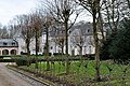
Le Plessis Castle

