
Le Neubourg
| Le Neubourg | ||
|---|---|---|
.svg)
|
|
|
| region | Normandy | |
| Department | Your | |
| Arrondissement | Bernay | |
| Canton | Le Neubourg | |
| Community association | Pays du Neubourg | |
| Coordinates | 49 ° 9 ' N , 0 ° 54' E | |
| height | 110-151 m | |
| surface | 9.91 km 2 | |
| Residents | 4,166 (January 1, 2017) | |
| Population density | 420 inhabitants / km 2 | |
| Post Code | 27110 | |
| INSEE code | 27428 | |
| Website | http://www.le-neubourg.fr/ | |
 Town Hall ( Hôtel de ville ) |
||

Le Neubourg is a French municipality with 4166 inhabitants (as of January 1 2017) in the department of Eure in the region of Normandy . It belongs to the Arrondissement Bernay and the canton Le Neubourg (bureau centralisateur) . The inhabitants are called Neubourgois .
geography
Le Neubourg is located about 22 kilometers north-west of Évreux on the plateau of Le Neubourg . Le Neubourg is surrounded by the neighboring municipalities of Vitot in the north, Crosville-la-Vieille in the east and northeast, Le Tremblay-Omonville in the south, Épreville-près-le-Neubourg in the southwest, Villez-sur-le-Neubourg in the west and Sainte- Opportune-du-Bosc in the northwest.
Population development
| year | 1962 | 1968 | 1975 | 1982 | 1990 | 1999 | 2006 | 2017 |
| Residents | 2835 | 3132 | 3498 | 3454 | 3639 | 3833 | 3964 | 4166 |
| Sources: Cassini and INSEE | ||||||||
Attractions
- Saint-Pierre-et-Saint-Paul church, monument historique since 1938
- The old castle, originally a castle from the 13th century, renovations from the 16th century, monument historique since 2002
- Castle of Le Champ-de-Bataille from the 17th century, monument historique since 1952/1971 and 1995
- Anatomy Museum
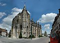
Saint-Pierre-et-Saint-Paul church

Old castle
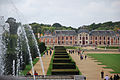
Le Champ de Bataille castle


Personalities
- Henry de Beaumont, 1st Earl of Warwick (died 1119), knight
- Louis Auzoux (1797-1880), anatomist
- Roger Boucher (1885–1918), organist and composer
Web links
Commons : Le Neubourg - collection of images, videos and audio files