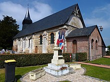
Duranville
| Duranville | ||
|---|---|---|
|
|
||
| region | Normandy | |
| Department | Your | |
| Arrondissement | Bernay | |
| Canton | Beuzeville | |
| Community association | Lieuvin Pays d'Auge | |
| Coordinates | 49 ° 9 ′ N , 0 ° 31 ′ E | |
| height | 162-178 m | |
| surface | 4.73 km 2 | |
| Residents | 153 (January 1, 2017) | |
| Population density | 32 inhabitants / km 2 | |
| Post Code | 27230 | |
| INSEE code | 27208 | |
 Town Hall (Mairie) of Duranville |
||
Duranville is a French municipality with 153 inhabitants (at January 1, 2017) in the Eure in the region Normandy (before 2016 Haute-Normandie ). It belongs to the arrondissement of Bernay and the canton of Beuzeville (until 2015 Thiberville ).
geography
Duranville is about twelve kilometers northwest of Bernay in the Lieuvin . Duranville is surrounded by the neighboring communities of Barville in the north and northwest, Folleville in the north, Le Theil-Nolent in the east, Malouy in the southeast, Bournainville-Faverolles in the south, Drucourt in the southwest and Fontaine-la-Louvet in the west.
| year | 1793 | 1806 | 1856 | 1886 | 1901 | 1954 | 1962 | 1968 | 1975 | 1982 | 1990 | 1999 | 2006 | 2013 |
|---|---|---|---|---|---|---|---|---|---|---|---|---|---|---|
| Residents | 250 | 323 | 306 | 285 | 209 | 171 | 169 | 162 | 151 | 185 | 171 | 173 | 167 | 157 |
Attractions
- Saint-Ouen church from the 12th century with alterations from the 17th century, since 1937/1938 Monument historique
Web links
Commons : Duranville - collection of images, videos, and audio files

