
Bosroumois
| Bosroumois | ||
|---|---|---|
|
||
| region | Normandy | |
| Department | Your | |
| Arrondissement | Bernay | |
| Canton | Bourgtheroulde-Infreville | |
| Community association | Roumois Seine | |
| Coordinates | 49 ° 17 ′ N , 0 ° 56 ′ E | |
| height | 107-162 m | |
| surface | 13.24 km 2 | |
| Residents | 3,588 (January 1, 2017) | |
| Population density | 271 inhabitants / km 2 | |
| Post Code | 27670 | |
| INSEE code | 27090 | |

Bosroumois is a French commune with 3,588 inhabitants (as of January 1 2017) in the department of Eure in the region of Normandy . It belongs to the Arrondissement of Bernay and the canton of Bourgtheroulde-Infreville and is a member of the Roumois Seine municipality .
geography
Bosroumois is located about 30 kilometers south-southwest of Rouen . Bosroumois is surrounded by the neighboring municipalities of La Londe in the north, Saint-Ouen-du-Tilleul in the east, Le Thuit de l'Oison in the south, Saint-Pierre-de-Bosguérard in the south and southwest and Grand Bourgtheroulde in the west.
history
On January 1, 2017, the previously independent municipalities of Le Bosc-Roger-en-Roumois and Bosnormand were merged to form the new municipality ( commune nouvelle ) Bosroumois. The seat of this newly created regional authority is in the district of Le Bosc-Roger-en-Roumois.
structure
| District | former INSEE code |
Area (km²) | Altitude (m) | Population (2017) | Density (inh. Per km²) |
|---|---|---|---|---|---|
| Le Bosc-Roger-en-Roumois (administrative headquarters) | 27090 | 9.90 | 107-162 | 3,261 | 327.0 |
| Bosnormand | 27093 | 3.34 | 124-161 | 327 | 98.2 |
Attractions
Le Bosc-Roger-en-Roumois
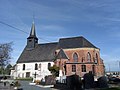
- Saint-Pierre church
Bosnormand
- Saint-Aubin church from the 17th century
- Amfreville Castle from the 17th century

Saint-Pierre church
Saint-Aubin church

