
Hauville
| Hauville | ||
|---|---|---|

|
|
|
| region | Normandy | |
| Department | Your | |
| Arrondissement | Bernay | |
| Canton | Bourg-Achard | |
| Community association | Roumois Seine | |
| Coordinates | 49 ° 24 ' N , 0 ° 46' E | |
| height | 80-148 m | |
| surface | 14.69 km 2 | |
| Residents | 1,279 (January 1, 2017) | |
| Population density | 87 inhabitants / km 2 | |
| Post Code | 27350 | |
| INSEE code | 27316 | |
 City Hall (Mairie) of Hauville |
||

Hauville is a commune with 1,279 inhabitants (as of January 1 2017) in the Eure in the region of Normandy . It belongs to the arrondissement of Bernay and is part of the canton of Bourg-Achard (until 2015: canton of Routot ). The inhabitants are called Hauvillais .
geography
Hauville is located about 23 kilometers west-southwest of Rouen in the Roumois countryside . Hauville is surrounded by the neighboring communities of La Mailleraye-sur-Seine in the north, Le Landin in the east and northeast, Honguemare-Guenouville in the east and southeast, Bouquetot in the south, Rougemontiers in the southwest, Routot in the west and southwest and La Haye-de-Routot in the West.
Population development
| year | 1896 | 1926 | 1936 | 1954 | 1962 | 1968 | 1975 | 1982 | 1990 | 1999 | 2006 | 2013 |
| Residents | 940 | 688 | 706 | 684 | 716 | 716 | 817 | 1,013 | 1,051 | 1,115 | 1,240 | 1,296 |
| Source: Cassini and INSEE | ||||||||||||
Attractions
- Saint-Paterne church from the 12th century
- Pierre Mill, built in 1258
- 18th century Saint-Paul castle

Saint-Paterne church
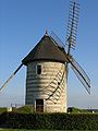
Pierre Mill

Saint-Paul Castle


Parish partnership
There is a partnership with the German municipality of Wangen in Baden-Württemberg.