Bregninge (Ærø Municipality)
| Bregninge | ||||
|
||||
| Basic data | ||||
|---|---|---|---|---|
| State : |
|
|||
| Region : | Syddanmark | |||
|
Municipality (since 2006) : |
Aero | |||
| Municipality / Office : (until the end of 2005) |
Ærøskøbing Kommune Fyns Amt |
|||
|
Harde / Amt: (until March 1970) |
Ærø Herred Svendborg Office |
|||
| Sogn : | Breginge Sogn | |||
| Coordinates : | 54 ° 54 ' N , 10 ° 19' E | |||
|
Population : (2020) |
<200 | |||
| Postal code : | 5970 Ærøskøbing | |||
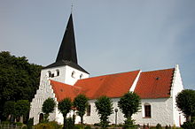
 The church in Bregninge |
||||
Bregninge is a Danish village with fewer than two hundred inhabitants (as of January 1, 2020) on Ærø . The village is located in the parish of the same name ( Bregninge Sogn ), which until 1970 belonged to Harde Ærø Herred in what was then Svendborg Amt (until 1864: Nordborg Amt ). With the dissolution of the Harden structure, the parish was included in the municipality of Ærøskøbing in the newly established Fyns Amt , the municipality in turn merged with the Marstal municipality on January 1, 2007 with the Marstal municipality in the municipality of Ærø , which is now part of the Syddanmark region.
Bregninge is about six kilometers southeast of Søby and also about six kilometers west of Ærøskøbing .
Web links
Commons : Bregninge - collection of images, videos and audio files


