
Breitenstein (Bavarian Prealps)
| Breitenstein | ||
|---|---|---|
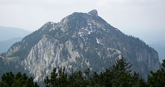
 Breitenstein from the south |
||
| height | 1622 m above sea level NN | |
| location | Bavaria , Germany | |
| Mountains | Bavarian Prealps ( Mangfall Mountains ) | |
| Dominance | 2.5 km → Wendelstein | |
| Notch height | 271 m ↓ saddle between Schweinsberg and Breitenstein | |
| Coordinates | 47 ° 43 '20 " N , 11 ° 59' 21" E | |
|
||
| Normal way | Fischbachau - Kesselalm - Hubertushütte - Breitenstein | |
 Northern part of the Wendelstein group with Bayrischzell |
||

The Breitenstein is a 1,622 m high mountain in the eastern part of the Bavarian Prealps , in the German state of Bavaria. The mountain has two peaks with the higher main summit in the east (1622 m) and the Bockstein sub-summit in the west (1575 m).
location
As the most north-westerly summit of the Wendelstein group , it is in an exposed position, but is in the shadow of the higher Wendelstein (1,838 m). To the north it breaks off with steep rock faces, the mostly forested south side slopes down a little more gently into the Leitzach valley . The ridge continues southeast over the Schweinsberg and the Türkenköpfl over to the Wendelstein; in a northerly direction, there are smaller elevations that lead to the Schwarzenberg , where the terrain slopes down into the Oberland. The Jenbachtal begins on the northeast side and leads down to Bad Feilnbach. The west side is characterized by extensive alpine pastures, as well as the area between the two peaks, where there is also a small lake, and the Hubertushütte, which is managed in the summer half-year . A geological specialty of the mountain is the so-called Breitensteiner Fensterl , a natural rock gate on the west side of the mountain.
Geotope
The Felstor Breitensteiner Window has been designated as an important geotope (geotope number: 182R005) and natural monument by the Bavarian State Office for the Environment .
Bases and routes

Several paths lead up to the Breitenstein, which can be used as a simple mountain hike (best time from May to November, the rest of the time there can be a lot of snow and there is a risk of avalanches). From Birkenstein near Fischbachau the normal route runs over the Kesselalm (1,278 m) and the Hubertushütte (1,535 m) in around two hours to the summit cross, another path leads over the Bucheralm and the 1,575 m high west summit (called Bockstein, with summit cross) also in two hours on the Breitenstein. A significantly longer ascent leads from Bad Feilnbach through the Jenbachtal past the Wirtsalm via Hubertushütte to the summit (time required around four and a half hours). A transition from Breitenstein past Schweinsberg to the southwest over to Wendelstein is also possible. Below the Schweinsberg summit, southeast of the Breitenstein, is the Aiblinger Hütte , a self-catering hut belonging to the Bad Aibling DAV section.
Winter mountaineering
In winter, numerous ski tourers and snowshoe hikers are on their way from Gasthaus Winklstüberl via the Bucheralm to the summit. The somewhat inconspicuous Schweinsberg (1,518 m) rises to the south, on which it is much quieter, but the view is also rewarding. On the normal route from the Kesselalm, on the other hand, you will mainly find tobogganers , as the Kesselalm is also open in winter in good weather and the forest road can be used as a toboggan run.
photos

East Summit (Main Summit)

West summit (Bockstein)
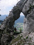
The Breitensteiner window

Breitenstein from the west
Breitenstein from the east


Literature and map
- Marianne and Emmeram Zebhauser: Alpine Club Guide Bavarian Prealps East . Bergverlag Rother , Munich 1992, ISBN 3-7633-1120-3
- Alpine Club Map Bavarian Alps 1: 25,000, sheet BY 16 Mangfall Mountains East
- Kompass hiking map 1.50.000, sheet WK 8, Tegernsee, Schliersee, Wendelstein, ISBN 3-85491-010-X
- Reinhard Rolle: Hut hiking between Garmisch and Berchtesgaden, Edition Förg, 2008, ISBN 978-3-933708-30-4 , pp. 54–56
Individual evidence
- ^ Bavarian State Office for the Environment, Geotop 182R005 Felstor Breitensteiner Window ( Memento from November 8, 2015 in the web archive archive.today ).