
Breeze (river)
| Breeze | ||
 Erlenbruchwald in Birkenwerder , living space at the Briese colony |
||
| Data | ||
| Water code | DE : 58192 | |
| location | Brandenburg , Germany | |
| River system | Elbe | |
| Drain over | Havel → Elbe → North Sea | |
| source | Wandlitzer See 52 ° 44 ′ 57 ″ N , 13 ° 26 ′ 6 ″ E |
|
| Source height | 48.3 m above sea level NHN | |
| muzzle | in the Havel in Birkenwerder Coordinates: 52 ° 41 ′ 17 ″ N , 13 ° 15 ′ 15 ″ E 52 ° 41 ′ 17 ″ N , 13 ° 15 ′ 15 ″ E |
|
| Mouth height | 31 m above sea level NHN | |
| Height difference | 17.3 m | |
| Bottom slope | 1 ‰ | |
| length | 17.1 km | |
| Flowing lakes | Rahmersee, Lubowsee, Briesesee, Boddensee | |
| Communities | Wandlitz, Mühlenbecker Land, Oranienburg, Birkenwerder | |
The Briese is a small, non-navigable tributary of the Havel . The breeze rises on the western Barnim in the Wandlitzer See and then flows through the Rahmer See and the Lubowsee . Its course is largely determined by a glacial channel . It continues through the Briesewald, an alder forest that used to be called "Der Briesen" and gave the river its name ( Slavic breza = birch). Here the Briese also touches the first settlement, the living space Kolonie Briese von Birkenwerder , which is a popular destination with the Briesesee as the entrance gate to the Briesetal nature reserve . The Briese then crosses the center of Birkenwerder and flows into the Havel near the western border with Hohen Neuendorf . The river was of economic importance in the past when peat was cut in its area and it drove three water mills between Zühlsdorf and Birkenwerder-Untermühle .
The upper course of the Briese is natural and its surroundings are popular with day trippers. Beaver dams or gnawed trees can be found again and again as a sign of the presence of this animal.
photos

Briese in
February 2007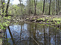
Beaver burrow near the estuary in 2010


Web links
Individual evidence
- ↑ River directory gewnet25 (Version 4.0, April 24, 2014) from the Ministry for Rural Development, Environment and Agriculture of the State of Brandenburg, accessed on May 4, 2015.