Rahmersee
| Rahmersee | ||
|---|---|---|

|
||
| View over the lake from south to northeast | ||
| Geographical location | Central Europe , Germany , Wandlitz | |
| Tributaries | Briese -Graben from the Wandlitzer See | |
| Drain | Briese direction Havel | |
| Places on the shore | Rahmersee settlement (south), Klosterfelde (northeast) | |
| Location close to the shore | Wensickendorf (northwest), belongs to the municipality of Oranienburg | |
| Data | ||
| Coordinates | 52 ° 44 ′ 54 " N , 13 ° 24 ′ 35" E | |
|
|
||
| Altitude above sea level | 50.0 | |
| surface | 90 ha | |
| length | 2 km | |
| width | 0.4 km (average) | |
| scope | 5 km | |
| Maximum depth | 9.0 m | |
| Middle deep | 5.0 m | |
The Rahmer See - also spelled Rahmersee ; historical spelling Ramer See - is located in the municipality of Wandlitz in Brandenburg . It is part of the Biesenthal-Wandlitz-Prendener lake area , which includes around 30 large and small lakes. The lake became famous for an artist colony built on its south bank in the 1920s. The lake is privately owned by a fishing family.
Origin, description and location
The ground moraine lake is a relic of the Vistula Ice Age , which formed together with the Lubowsee , the Wandlitzer See , the Liepnitzsee and the combination Obersee - Hellsee . Its north-west bank in particular is bordered by more towering terminal moraines .
In connection with the history of Wensickendorf and its surroundings it is reported that there were early settlers on this lake and that the body of water was named Lake Rademer in documents from the Middle Ages .
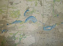
The Briese river connects the slightly higher situated Wandlitzer See with the Rahmersee, which in turn is connected with the Lubowsee via the Briese. The lake is about 2 kilometers long in an east-west direction and measures around 540 meters at its widest point, a larger bay about in the middle.
The Rahmer See is affected by the district of Zühlsdorf (municipality of Mühlenbecker Land ) in the southwest and the Wandlitz districts of Wandlitz in the southeast and Stolzenhagen in the north. The part of the settlement in the northwest area belongs to Wensickendorf and thus to the city of Oranienburg .
Flora and fauna
In addition to the pines, beeches and oaks that are widespread in the Märkisch region, alder trees , sundew , butterwort and rosemary heather can also be found in the wetlands on the lake shore . Rushes , reeds and cattails have settled in the shallow water area. This relatively impenetrable vegetation forms the basis of life for insects , butterflies and songbirds, as well as water birds and amphibians . Pike , carp , tench , eel and rudd feel at home in the lake . Occasionally pikeperch have been caught and crabs have been observed. Because it is a privately owned lake, it does not have a number from the German Angler Association, but simply the number 1435 used by anglers.
Bank areas and surroundings
Inn
The shores of the Rahmer See are built up in parts, there is no continuous shoreline hiking trail. The undeveloped areas are hilly or boggy .
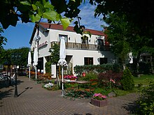
The best known is the hotel and inn Zur Waldschänke , which was built on the road near the south bank and opened in the 1960s as the Waldschänke restaurant . The chosen name is made clear in the rustic furnishings with hunting trophies and also with the hearty Brandenburg cuisine. After 1990 it was bought by a private citizen who expanded it into a hotel and expanded the catering facilities. During the year there are various cultural events such as celebrations for Women's Day or Children's Day, as well as seasonal culinary evenings.
Housing estates
An artists' colony was established on the southeast bank in the 1920s , which officially belonged to what was then the village of Wandlitz . This first settlement became what is now the Rahmersee colony, consisting partly of permanent villas and partly of weekend houses. It will be expanded gradually. On the north-east bank, housing developments later developed around today's federal road 273 . These are the Am Rahmer See settlement as part of the village of Wensickendorf and a residential area belonging to Klosterfelde.
Bathing establishment
In the southwestern section of the bank, the community at that time set up an open-air swimming pool with boat rental, which was leased to a private individual in 1993. The tenant family runs the Rahmer See lido including a small snack bar as a natural recreational facility. The outdoor pool has shallow water access suitable for children, a jetty, diving tower and two slides. There is also a beach volleyball court, table tennis and boat rental.
Traffic around the lake
Two roads that open up the area run not directly on the lake, but a short distance from its banks: the federal road 273 (north) and the district road K6004 with the Wandlitzer Chaussee – Zühlsdorfer Chaussee (south). A bus line also operates here.
literature
- 1000 ways around Berlin. Map book and hiking guide ; Ullstein-Verlag, Berlin (no year, probably in the 1930s); Pages 58 and 97
- Angler Guide Brandenburg, Volume 4 - the Wandlitzer Lakes , future press
- Anja Reinbothe: And nüscht like out to Wandlitz. - Little escapes, part 93: Weekend in the Waldschänke at the Rahmersee. In: Berliner Morgenpost of April 27, 2012
Web links
Individual evidence
- ↑ Wensickendorf; Historical , accessed June 7, 2012
- ↑ Volkmar Gäbler: hiking guide Wandlitzsee - Liepnitzsee. The most beautiful hikes between Bernau and Oranienburg. Tourist Verlag Kümmerly + Frey, 1993/94, ISBN 3-350-00836-4 , p. 49f.
- ↑ Brief information on fish stocks in the Rahmer See on anglerboard.de , accessed on June 7, 2012
- ↑ Information board at the Rahmer See lido
- ↑ Water profile on anglermap.de
-
^ Website of the Waldschänke am Rahmer See , accessed on June 7, 2012
and a conversation with the owner on June 9, 2012 -
↑ Website with a brief introduction to the Rahmer See lido , accessed on June 7, 2012
and a conversation with the leaseholder on June 9, 2012 - ↑ Title image of the book Anglerführer Brandenburg and brief synopsis with reference to the Rahmer See


