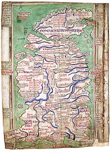
Map of Britain by Matthew Paris
The Matthew Paris Map of Britain is a medieval map of Great Britain created by Matthew Paris around 1250 .
The map, oriented to the north , shows England , Wales and Scotland , the latter being represented considerably too small and with little information compared to the other two areas and thus represented rather symbolically.
The most important feature of the map is a major vertical axis that begins in the north of England and extends south to the coast of the English Channel . Lined up on this axis are the most important cities at the time, at intervals of one to two day trips . The initial town is Newcastle upon Tyne , followed by Durham , Northallerton , Boroughbridge , Pontefract , Doncaster , Blyth , Belvoir , Leicester , Northampton , Dunstable , St Albans , London , Rochester , Canterbury and finally Dover .
In addition, the map contains numerous place names , rivers , references to topographical features and a large number of other information. The northern end of England against Scotland make presentations of Hadrian Walles and Antonine .
The map of Britain by Matthew Paris, five copies of which have survived to this day, is an important testimony to medieval cartography , as it is one of the earliest examples of medieval maps that show the efforts to reproduce geographical facts in a realistic manner.
literature
- Ingrid Kretschmer ao: Lexicon for the history of cartography. From the beginning to the First World War . Volume 2: M - Z . Verlag Franz Deuticke, Vienna 1986, ISBN 3-7005-4562-2 , ( Cartography and its peripheral areas C 2).
- Ivan Kupčík: Old Maps. From antiquity to the end of the 19th century . Dausien-Verlag, Hanau 1980, ISBN 3-7684-1873-1 .
